|
search place name
|
||
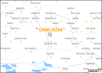
Chwaliszew (Poland)Chwaliszew is a town in Poland. An overview map of the region around Chwaliszew is displayed below.
regional and 3d topo map of Chwaliszew, Poland ::
Chwaliszew airports ::
The nearest airport is WRO - Wroclaw Strachowice, located 75.8 km south west of Chwaliszew.
Other airports nearby include POZ - Poznan Lawica (98.6 km north west), IEG - Zielona Gora Babimost (131.2 km north west), KTW - Katowice Pyrzowice (169.9 km south east), OSR - Ostrava Mosnov (221.1 km south), Nearby towns ::
Chwaliszewek (1.9km south) //
Piaski (2.2km south west) //
Sulmierzyce (3.7km south) //
Smoszew (3.0km north west) //
Biadki (3.9km north) //
Warszty (3.0km north east) //
Jasne Pole (5.6km north) //
Gorzupia (5.7km north) //
Duszna Górka (6.0km north) //
Różopole (7.4km north) //
Kolęda (7.4km south) //
Chruszczyn (5.0km east) //
Tomnice (6.5km north west) //
Świnków (5.9km north east) //
Ostrowąsy (7.2km south west) //
Durzyn (7.2km north west) //
Kobierno (8.2km north west) //
[all distances 'as the bird flies' and approximate] 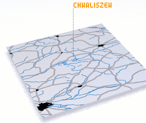 Places with similar names to Chwaliszew, Poland ::
// Chwałęcice (PL)
// Chwalęcice (PL)
Disclaimer :: Information on this page comes without warranty of any kind |
||
|
Where is Chwaliszew? Elevation and coordinates ::
Latitude (lat): 51°39'0"N Longitude (lon): 17°32'0"E
Elevation (approx.): 128m (map arrows pan, magnifying glasses zoom) |
||
|
Visiting Chwaliszew? Hotel/Accommodation ::
Book a hotel in Chwaliszew Travel Guide ::
Buy a travel guide for Poland rental cars ::
car rental offers GPS waypoint ::
download a GPX waypoint (PoI) of Chwaliszew for your GPS receiver
|
||