|
search place name
|
||
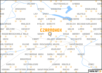
Czarnówek (Poland)Czarnówek is a town in Poland. An overview map of the region around Czarnówek is displayed below.
regional and 3d topo map of Czarnówek, Poland ::
Czarnówek airports ::
The nearest airport is WAW - Warsaw Okecie, located 178.8 km south west of Czarnówek.
Other airports nearby include KGD - Kaliningrad Khrabrovo (179.9 km north west), Nearby towns ::
Czarnowo (1.9km south) //
Chojnowo (1.1km east) //
Załuski (1.9km south) //
Włosty (1.9km north) //
Mazewo (2.2km south east) //
Łodygowo (2.2km north west) //
Świdry (2.2km west) //
Skarzyn (3.7km north) //
Jambrzyki (2.9km south east) //
Dołęgi (3.9km south) //
Brzeźno (3.9km south) //
Niedźwiadna (3.9km south) //
Myśliki (4.3km north west) //
Lipińskie (5.6km north) //
Skaje (3.3km east) //
Wojsławy (5.7km south) //
Cibory (3.8km south west) //
Rakowo (3.8km north east) //
Stawiane (6.0km south) //
Rogale Wielkie (6.0km north) //
Obrytki (5.0km south east) //
Kurki (5.0km south west) //
Wojny (6.0km north) //
Surały (7.4km south) //
Grądy Michały (7.5km south) //
Wólka (4.8km north east) //
Dmusy (7.5km north) //
Pasichy (7.7km south) //
Sokoły (5.8km south east) //
[all distances 'as the bird flies' and approximate]  Places with similar names to Czarnówek, Poland ::
// Czarnówiec (PL)
// Czarnowiec (PL)
Disclaimer :: Information on this page comes without warranty of any kind |
||
|
Where is Czarnówek? Elevation and coordinates ::
Latitude (lat): 53°35'0"N Longitude (lon): 22°13'0"E
Elevation (approx.): 129m (map arrows pan, magnifying glasses zoom) |
||
|
Visiting Czarnówek? Hotel/Accommodation ::
Book a hotel in Czarnówek Travel Guide ::
Buy a travel guide for Poland rental cars ::
car rental offers GPS waypoint ::
download a GPX waypoint (PoI) of Czarnówek for your GPS receiver
|
||