|
search place name
|
||
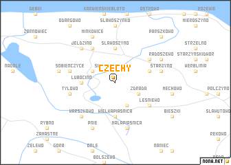
Czechy (Poland)Czechy is a town in Poland. An overview map of the region around Czechy is displayed below.
regional and 3d topo map of Czechy, Poland ::
Czechy airports ::
The nearest airport is GDN - Gdansk Lecha Walesy, located 43.2 km south east of Czechy.
Other airports nearby include OSP - Slupsk Redzikowo (76.1 km west), KLR - Kalkmar Kalmar (248.4 km north west), Nearby towns ::
Świecino (2.1km north west) //
Zdrada (2.8km south east) //
Domatowo (2.8km south east) //
Domatówko (3.9km south) //
Karlikowo (2.8km north west) //
Wielka Piaśnica (5.6km south) //
Lubocino (3.2km west) //
Sławoszyno (5.6km north) //
Głuszewo (3.7km north east) //
Leśniewo (4.9km south east) //
Krokowa (6.0km north) //
Kłanino (4.9km north east) //
Mała Piaśnica (7.5km south) //
Tyłowo (4.7km south west) //
Sobieńczyce (4.7km north west) //
Starzyno (4.7km north east) //
Warszkowo (6.4km south west) //
Goszczyno (6.4km north west) //
Jeldzino (6.4km north west) //
Pnie (7.7km south) //
Minkowice (7.7km north) //
Radoszewo (5.7km north east) //
Parszkowo (8.6km north east) //
[all distances 'as the bird flies' and approximate] 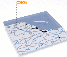 Places with similar names to Czechy, Poland ::
Disclaimer :: Information on this page comes without warranty of any kind |
||
|
Where is Czechy? Elevation and coordinates ::
Latitude (lat): 54°44'0"N Longitude (lon): 18°12'0"E
Elevation (approx.): 72m (map arrows pan, magnifying glasses zoom) |
||
|
Visiting Czechy? Hotel/Accommodation ::
Book a hotel in Czechy Travel Guide ::
Buy a travel guide for Poland rental cars ::
car rental offers GPS waypoint ::
download a GPX waypoint (PoI) of Czechy for your GPS receiver
|
||