|
search place name
|
||
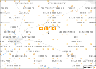
Czernice (Poland)Czernice is a town in Poland. An overview map of the region around Czernice is displayed below.
regional and 3d topo map of Czernice, Poland ::
Czernice airports ::
The nearest airport is WAW - Warsaw Okecie, located 83.2 km south of Czernice.
Other airports nearby include KGD - Kaliningrad Khrabrovo (221.7 km north), Nearby towns ::
Opinogóra (1.1km west) //
Opinogóra Górna (1.1km west) //
Opinogóra Dolna (2.2km north west) //
Załuże Patory (2.2km north east) //
Bogucin (2.2km south east) //
Pałuki (2.2km south east) //
Bacze (3.9km north) //
Załuże (3.9km north) //
Załuże Imbrzyki (3.9km north) //
Elżbiecin (2.9km south west) //
Przytoka Pałuki (2.9km south east) //
Pomorze (4.3km south west) //
Dzbonie (4.3km north west) //
Sosnowo (4.3km north east) //
Rębowo (3.4km east) //
Nasierowo Dolne (5.6km south) //
Kołaki Budzyno (5.6km north) //
Nasierowo Górne (5.7km south) //
Nasierowo Dziurawieniec (5.7km south) //
Wilkowo (5.7km north) //
Kąty (4.5km west) //
Wólka Łanięcka (4.5km east) //
Kołaczków (4.5km east) //
Wierzbowo (7.4km north) //
Władysławów (4.8km west) //
Wola Wierzbowska (7.5km north) //
Chrzanowo (5.8km south west) //
Kotermań (5.8km north west) //
Kobylin-Paulinowo (5.8km south east) //
[all distances 'as the bird flies' and approximate]  Places with similar names to Czernice, Poland ::
Disclaimer :: Information on this page comes without warranty of any kind |
||
|
Where is Czernice? Elevation and coordinates ::
Latitude (lat): 52°54'0"N Longitude (lon): 20°44'0"E
Elevation (approx.): 134m (map arrows pan, magnifying glasses zoom) |
||
|
Visiting Czernice? Hotel/Accommodation ::
Book a hotel in Czernice Travel Guide ::
Buy a travel guide for Poland rental cars ::
car rental offers GPS waypoint ::
download a GPX waypoint (PoI) of Czernice for your GPS receiver
|
||