|
search place name
|
||
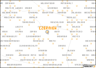
Czerniew (Poland)Czerniew is a town in Poland. An overview map of the region around Czerniew is displayed below.
regional and 3d topo map of Czerniew, Poland ::
Czerniew airports ::
The nearest airport is WAW - Warsaw Okecie, located 74.7 km east of Czerniew.
Other airports nearby include KTW - Katowice Pyrzowice (205.3 km south), Nearby towns ::
Karsznice Duże (1.9km south) //
Karsznice Małe (2.2km south west) //
Kiernozia (2.2km north west) //
Osiny (2.3km east) //
Sokołów (2.9km south west) //
Mastki (3.9km south) //
Wiśniewo (2.9km north east) //
Niespusza (4.3km south west) //
Niedzieliska (4.3km north east) //
Zofiów (3.4km west) //
Skowroda (3.9km south east) //
Złąków Borowy (3.9km south west) //
Przemysłów (6.0km south) //
Sewerynów (7.4km north) //
Wyborów (7.5km south) //
Olszyny (4.9km east) //
Osmolin (6.5km north west) //
Chąśno (6.5km south east) //
Tomaszówka (5.9km north west) //
Krzyżyk Chróśliński (5.9km north east) //
Złąków Kościelny (7.2km south west) //
Aleksandrów (7.2km north east) //
Starópol (8.2km north west) //
Romanów (8.2km north east) //
Brzezia (8.2km north east) //
[all distances 'as the bird flies' and approximate]  Places with similar names to Czerniew, Poland ::
Disclaimer :: Information on this page comes without warranty of any kind |
||
|
Where is Czerniew? Elevation and coordinates ::
Latitude (lat): 52°15'0"N Longitude (lon): 19°53'0"E
Elevation (approx.): 93m (map arrows pan, magnifying glasses zoom) |
||
|
Visiting Czerniew? Hotel/Accommodation ::
Book a hotel in Czerniew Travel Guide ::
Buy a travel guide for Poland rental cars ::
car rental offers GPS waypoint ::
download a GPX waypoint (PoI) of Czerniew for your GPS receiver
|
||