|
search place name
|
||
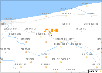
Dygowo (Koszalin, Poland)Dygowo is a town in the Koszalin region of Poland. An overview map of the region around Dygowo is displayed below.
regional and 3d topo map of Dygowo, Poland ::
Dygowo airports ::
The nearest airport is SZZ - Szczechin Goleniow, located 81.2 km south west of Dygowo.
Other airports nearby include OSP - Slupsk Redzikowo (98.4 km north east), RNN - Bornholm Ronne (120.6 km north west), POZ - Poznan Lawica (204.4 km south), IEG - Zielona Gora Babimost (222.1 km south), Nearby towns ::
Bardy (2.1km south west) //
Czernin (2.2km west) //
Miechęcino (2.9km south east) //
Włościbórz (4.3km south east) //
Kukinia (4.9km north east) //
Jazy (4.7km south east) //
Skronie (7.5km south) //
Stramnica (4.7km north west) //
Bagicz (7.5km north) //
Grąbnica (8.1km north east) //
[all distances 'as the bird flies' and approximate] 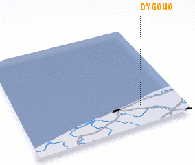 Places with similar names to Dygowo, Poland ::
Disclaimer :: Information on this page comes without warranty of any kind |
||
|
Where is Dygowo? Elevation and coordinates ::
Latitude (lat): 54°8'0"N Longitude (lon): 15°43'0"E
Elevation (approx.): 26m (map arrows pan, magnifying glasses zoom) |
||
|
Visiting Dygowo? Hotel/Accommodation ::
Book a hotel in Dygowo Travel Guide ::
Buy a travel guide for Poland rental cars ::
car rental offers GPS waypoint ::
download a GPX waypoint (PoI) of Dygowo for your GPS receiver
|
||