|
search place name
|
||
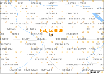
Felicjanów (Poland)Felicjanów is a town in Poland. An overview map of the region around Felicjanów is displayed below.
regional and 3d topo map of Felicjanów, Poland ::
Felicjanów airports ::
The nearest airport is WRO - Wroclaw Strachowice, located 166.9 km south west of Felicjanów.
Other airports nearby include KTW - Katowice Pyrzowice (168.8 km south), KRK - Krakow Balice (222.3 km south), Nearby towns ::
Wola Przedmiejska (1.9km south) //
Brzeziny (2.2km north west) //
Kolonia Wielenin (3.7km north) //
Uniejów (2.9km south west) //
Józefów (3.9km south) //
Kolonia Orzeszków (2.9km north west) //
Biernacice (2.9km south east) //
Wielenin (3.9km north) //
Szarów Księży (4.4km south east) //
Orzeszków (4.4km north west) //
Pągów (4.4km north east) //
Grocholice (5.6km south) //
Boczki (5.6km south) //
Wojciechów (3.4km east) //
Kościelnica (3.4km west) //
Kolonia Balin (5.7km south) //
Balin (5.7km south) //
Czepów Górny (5.7km north) //
Kozanki Wielkie (5.7km north) //
Spicymierz (5.0km south west) //
Czepów Średni (6.0km north) //
Niewiesz (6.0km south) //
Zaborów (6.0km north) //
Lipnica (7.4km south) //
Rożniatów (7.4km north) //
Zelgoszcz (4.6km east) //
Dominikowice (7.5km south) //
Izabela (7.5km south) //
Ostrosko (4.9km west) //
[all distances 'as the bird flies' and approximate]  Places with similar names to Felicjanów, Poland ::
Disclaimer :: Information on this page comes without warranty of any kind |
||
|
Where is Felicjanów? Elevation and coordinates ::
Latitude (lat): 51°59'0"N Longitude (lon): 18°50'0"E
Elevation (approx.): 117m (map arrows pan, magnifying glasses zoom) |
||
|
Visiting Felicjanów? Hotel/Accommodation ::
Book a hotel in Felicjanów Travel Guide ::
Buy a travel guide for Poland rental cars ::
car rental offers GPS waypoint ::
download a GPX waypoint (PoI) of Felicjanów for your GPS receiver
|
||