|
search place name
|
||
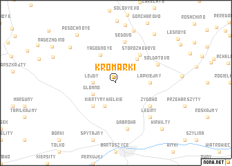
Kromarki (Poland)Kromarki is a town in Poland. An overview map of the region around Kromarki is displayed below.
regional and 3d topo map of Kromarki, Poland ::
Kromarki airports ::
The nearest airport is KGD - Kaliningrad Khrabrovo, located 61.6 km north of Kromarki.
Nearby towns ::
Lejdy (2.2km west) //
Głomno (2.8km south west) //
Kiertyny Wielkie (3.9km south) //
Yagodnoye (4.7km north) //
Pogranichnoye (4.3km north east) //
Kiertyny Małe (4.3km south west) //
Łapkiejmy (3.2km east) //
Storozhevoye (5.0km north east) //
Żydowo (4.9km south east) //
Sedovo (6.7km north) //
Soldatovo (4.9km north east) //
Dąbrowa (7.5km south) //
Leginy (6.4km south east) //
Domnovo (8.6km north) //
Dubki (7.2km north west) //
Cherëmukhovo (8.7km north east) //
Pesochnoye (8.6km north west) //
Wirwilty (8.6km south east) //
Skitno (8.6km south east) //
[all distances 'as the bird flies' and approximate]  Places with similar names to Kromarki, Poland ::
// Cromberg (US)
// Grimberg (DE)
// Grimberg (DE)
// Gromberg (DE)
// Grummark (DE)
// Kram-Brook (DE)
// Krummbrook (DE)
// Kramarka (PL)
// Kramarka (UA)
// Karamorka (RU)
Disclaimer :: Information on this page comes without warranty of any kind |
||
|
Where is Kromarki? Elevation and coordinates ::
Latitude (lat): 54°21'0"N Longitude (lon): 20°48'0"E
Elevation (approx.): 101m (map arrows pan, magnifying glasses zoom) |
||
|
Visiting Kromarki? Hotel/Accommodation ::
Book a hotel in Kromarki Travel Guide ::
Buy a travel guide for Poland rental cars ::
car rental offers GPS waypoint ::
download a GPX waypoint (PoI) of Kromarki for your GPS receiver
|
||