|
search place name
|
||
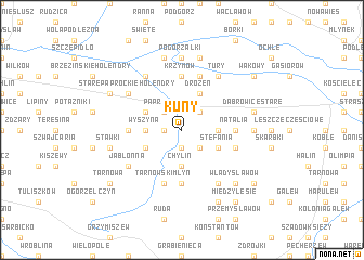
Kuny (Poland)Kuny is a town in Poland. An overview map of the region around Kuny is displayed below.
regional and 3d topo map of Kuny, Poland ::
Kuny airports ::
The nearest airport is POZ - Poznan Lawica, located 113.7 km west of Kuny.
Other airports nearby include WRO - Wroclaw Strachowice (158.3 km south west), KTW - Katowice Pyrzowice (191.8 km south), Nearby towns ::
Beznazwa (1.1km west) //
Piorunów (1.9km south) //
Paprotnia (2.2km north west) //
Genowefa Piorunowska (2.2km north east) //
Kamionka (2.2km south east) //
Chylin (3.7km south) //
Wyszyna (2.3km west) //
Leonia (2.3km east) //
Drożeń (3.9km north) //
Kałek (2.9km north west) //
Kolonia Wyszyna (2.9km south west) //
Stefania (2.9km south east) //
Głogowa (5.6km south) //
Smolnik (3.4km west) //
Natalia (3.4km east) //
Krzymów (5.6km north) //
Tarnowski Młyn (5.7km south) //
Milinów (3.9km south east) //
Helenów (5.7km north) //
Jabłonna (5.0km south west) //
Stare Paprockie Holendry (5.0km north west) //
Borowo (6.0km north) //
Felicjanów (6.0km south) //
Tury (6.0km north) //
Piersk (7.4km north) //
Dąbrowice Nowe (4.5km east) //
Pogorzałki (7.4km north) //
Stawki (4.9km west) //
Drążno-Holendry (7.5km north) //
[all distances 'as the bird flies' and approximate]  Places with similar names to Kuny, Poland ::
Disclaimer :: Information on this page comes without warranty of any kind |
||
|
Where is Kuny? Elevation and coordinates ::
Latitude (lat): 52°9'0"N Longitude (lon): 18°26'0"E
Elevation (approx.): 94m (map arrows pan, magnifying glasses zoom) |
||
|
Visiting Kuny? Hotel/Accommodation ::
Book a hotel in Kuny Travel Guide ::
Buy a travel guide for Poland rental cars ::
car rental offers GPS waypoint ::
download a GPX waypoint (PoI) of Kuny for your GPS receiver
|
||