|
search place name
|
||
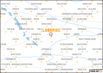
Luboniec (Poland)Luboniec is a town in Poland. An overview map of the region around Luboniec is displayed below.
regional and 3d topo map of Luboniec, Poland ::
Luboniec airports ::
The nearest airport is POZ - Poznan Lawica, located 38.9 km north west of Luboniec.
Other airports nearby include IEG - Zielona Gora Babimost (97.1 km west), WRO - Wroclaw Strachowice (120.6 km south), KTW - Katowice Pyrzowice (228.7 km south east), Nearby towns ::
Lubonieczek (1.9km south) //
Czarnotki (1.9km south) //
Płaczki (3.7km north) //
Śnieciska (3.9km north) //
Polwica (2.9km north west) //
Majdany (2.9km south west) //
Annopole (5.6km north) //
Mądre (3.4km east) //
Zaniemyśl (3.4km west) //
Pigłowice (3.9km north east) //
Kępa Mała (5.7km south) //
Zwola (3.9km south west) //
Gogolewko (6.0km south) //
Młodzikówko (5.0km south east) //
Jeziory Małe (4.5km west) //
Zaborowo (7.5km south) //
Pętkowo (6.5km north east) //
Młodzikowo (6.5km south east) //
Winna (6.5km north west) //
Koszuty (7.8km north) //
Sroczewo (7.8km south) //
Grodzewo (5.9km south west) //
Dębiec (8.2km north west) //
Bożydar (7.2km north west) //
Środa Wielkopolska (8.7km north east) //
Gogolewo (8.7km south east) //
[all distances 'as the bird flies' and approximate] 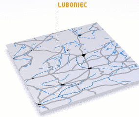 Places with similar names to Luboniec, Poland ::
Disclaimer :: Information on this page comes without warranty of any kind |
||
|
Where is Luboniec? Elevation and coordinates ::
Latitude (lat): 52°10'0"N Longitude (lon): 17°13'0"E
Elevation (approx.): 76m (map arrows pan, magnifying glasses zoom) |
||
|
Visiting Luboniec? Hotel/Accommodation ::
Book a hotel in Luboniec Travel Guide ::
Buy a travel guide for Poland rental cars ::
car rental offers GPS waypoint ::
download a GPX waypoint (PoI) of Luboniec for your GPS receiver
|
||