|
search place name
|
||
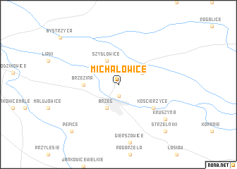
Michałowice (Poland)Michałowice is a town in Poland. An overview map of the region around Michałowice is displayed below.
regional and 3d topo map of Michałowice, Poland ::
Michałowice airports ::
The nearest airport is WRO - Wroclaw Strachowice, located 48.5 km north west of Michałowice.
Other airports nearby include KTW - Katowice Pyrzowice (121.7 km east), OSR - Ostrava Mosnov (139.4 km south), PED - Pardubice (157.2 km south west), PRV - Prerov (162.2 km south), Nearby towns ::
Dobrzyń (1.9km south) //
Brzeg (3.9km south) //
Szydłowice (3.9km north) //
Lubsza (3.0km north east) //
Brzezina (3.5km west) //
Kościerzyce (5.1km south east) //
Kruszyna (7.3km south east) //
Pępice (8.8km south west) //
Strzelniki (8.8km south east) //
[all distances 'as the bird flies' and approximate]  Places with similar names to Michałowice, Poland ::
// Michałowice (PL)
// Michałowice (PL)
// Michałowice (PL)
// Michałowice (PL)
// Michałowice (PL)
// Michałowice (PL)
Disclaimer :: Information on this page comes without warranty of any kind |
||
|
Where is Michałowice? Elevation and coordinates ::
Latitude (lat): 50°53'0"N Longitude (lon): 17°29'0"E
Elevation (approx.): 131m (map arrows pan, magnifying glasses zoom) |
||
|
Visiting Michałowice? Hotel/Accommodation ::
Book a hotel in Michałowice Travel Guide ::
Buy a travel guide for Poland rental cars ::
car rental offers GPS waypoint ::
download a GPX waypoint (PoI) of Michałowice for your GPS receiver
|
||