|
search place name
|
||
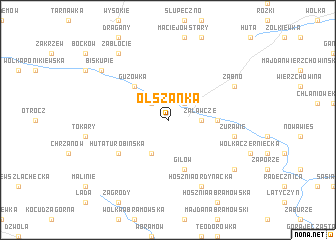
Olszanka (Poland)Olszanka is a town in Poland. An overview map of the region around Olszanka is displayed below.
regional and 3d topo map of Olszanka, Poland ::
Olszanka airports ::
The nearest airport is RZE - Rzeszow Jasionka, located 92.9 km south west of Olszanka.
Other airports nearby include LWO - Lvov Lviv Intl (142.4 km south east), WAW - Warsaw Okecie (193.1 km north west), Nearby towns ::
Turobin (2.2km north east) //
Tarnawa (2.2km north west) //
Załawcze (2.3km east) //
Grudki (3.9km south) //
Guzówka (4.4km north west) //
Rokitów (3.5km east) //
Gilów (5.7km south) //
Huta Turobińska (5.1km south west) //
Żurawie (5.0km east) //
Żabno (6.0km north east) //
Hosznia Ordynacka (7.8km south) //
Podlesie (7.3km south east) //
Zabłocie (8.2km north west) //
Biskupie (7.3km north west) //
[all distances 'as the bird flies' and approximate] 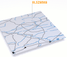 Places with similar names to Olszanka, Poland ::
Disclaimer :: Information on this page comes without warranty of any kind |
||
|
Where is Olszanka? Elevation and coordinates ::
Latitude (lat): 50°49'0"N Longitude (lon): 22°43'0"E
Elevation (approx.): 229m (map arrows pan, magnifying glasses zoom) |
||
|
Visiting Olszanka? Hotel/Accommodation ::
Book a hotel in Olszanka Travel Guide ::
Buy a travel guide for Poland rental cars ::
car rental offers GPS waypoint ::
download a GPX waypoint (PoI) of Olszanka for your GPS receiver
|
||