|
search place name
|
||
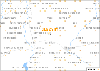
Olszyny (Poland)Olszyny is a town in Poland. An overview map of the region around Olszyny is displayed below.
regional and 3d topo map of Olszyny, Poland ::
Olszyny airports ::
The nearest airport is KRK - Krakow Balice, located 41.0 km north east of Olszyny.
Other airports nearby include KTW - Katowice Pyrzowice (65.5 km north), OSR - Ostrava Mosnov (87.4 km west), TAT - Poprad Tatry (115.2 km south east), SLD - Sliac (140.8 km south), Nearby towns ::
Witkowice (1.9km north) //
Butowice (3.7km south) //
Góry Kęckie (2.4km west) //
Nideckie Podlesie (2.4km east) //
Latonka (3.0km north east) //
Malec (4.4km north west) //
Osiek (5.6km north) //
Kęty (4.0km south west) //
Nowa Wieś (4.0km north west) //
Nidek (4.0km north east) //
Czaniec (6.1km south west) //
Roczyny (6.1km south east) //
Brzezinka (7.5km south) //
Głębowice (6.6km north east) //
Kobiernice (6.0km south west) //
Bukowiec (7.8km south) //
Łęki (7.3km north west) //
Andrychów (7.3km south east) //
Granice Głębowskie (8.8km north east) //
Sułkowice (8.8km south east) //
[all distances 'as the bird flies' and approximate] 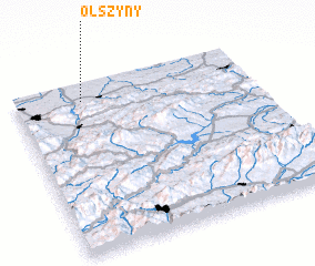 Places with similar names to Olszyny, Poland ::
Disclaimer :: Information on this page comes without warranty of any kind |
||
|
Where is Olszyny? Elevation and coordinates ::
Latitude (lat): 49°54'0"N Longitude (lon): 19°17'0"E
Elevation (approx.): 291m (map arrows pan, magnifying glasses zoom) |
||
|
Visiting Olszyny? Hotel/Accommodation ::
Book a hotel in Olszyny Travel Guide ::
Buy a travel guide for Poland rental cars ::
car rental offers GPS waypoint ::
download a GPX waypoint (PoI) of Olszyny for your GPS receiver
|
||