|
search place name
|
||
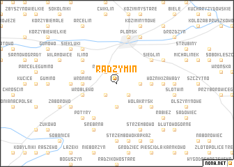
Radzymin (Poland)Radzymin is a town in Poland. An overview map of the region around Radzymin is displayed below.
regional and 3d topo map of Radzymin, Poland ::
Radzymin airports ::
The nearest airport is WAW - Warsaw Okecie, located 60.5 km south east of Radzymin.
Other airports nearby include GDN - Gdansk Lecha Walesy (237.8 km north west), Nearby towns ::
Jeżewo (1.9km north) //
Radzyminek (2.2km north west) //
Turowo (2.2km south east) //
Skwary Dąbrowe (2.2km south west) //
Krzykosy (2.3km east) //
Naruszewo (3.7km south) //
Wola Krysk (4.3km south east) //
Wronino (3.4km west) //
Michałowo (3.4km west) //
Postruże (3.4km east) //
Postruże Duże (3.4km east) //
Postruże Małe (3.4km east) //
Wożniki (3.4km east) //
Cholewy (3.9km north west) //
Wróblewo (3.9km south west) //
Siedlin (5.0km north east) //
Ilino (5.0km north west) //
Grąbczewo (6.0km south) //
Krysk (5.0km south east) //
Wożniki Zawady (4.5km east) //
Wożniki Pruszyn (4.5km east) //
Beszyno Michałowo (4.5km west) //
Beszyno (4.5km west) //
Płońsk (7.5km north) //
Potyry (6.5km south west) //
Ilinko (6.5km north west) //
Michowo (7.7km north) //
Dalanowo (5.8km north east) //
Strzembowo (7.7km south) //
[all distances 'as the bird flies' and approximate] 
Disclaimer :: Information on this page comes without warranty of any kind |
||
|
Where is Radzymin? Elevation and coordinates ::
Latitude (lat): 52°34'0"N Longitude (lon): 20°22'0"E
Elevation (approx.): 116m (map arrows pan, magnifying glasses zoom) |
||
|
Visiting Radzymin? Hotel/Accommodation ::
Book a hotel in Radzymin Travel Guide ::
Buy a travel guide for Poland rental cars ::
car rental offers GPS waypoint ::
download a GPX waypoint (PoI) of Radzymin for your GPS receiver
|
||