|
search place name
|
||
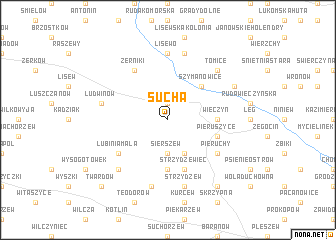
Sucha (Poland)Sucha is a town in Poland. An overview map of the region around Sucha is displayed below.
regional and 3d topo map of Sucha, Poland ::
Sucha airports ::
The nearest airport is POZ - Poznan Lawica, located 74.8 km north west of Sucha.
Other airports nearby include WRO - Wroclaw Strachowice (116.3 km south west), IEG - Zielona Gora Babimost (131.1 km west), KTW - Katowice Pyrzowice (196.8 km south east), Nearby towns ::
Prusinów (1.9km north) //
Sierszew (3.7km south) //
Pieruszyczki (3.9km south) //
Czołnochów (4.4km north east) //
Szymanowice (4.4km north east) //
Wieczyn (3.4km east) //
Parzew (5.6km south) //
Pieruszyce (3.9km south east) //
Strzydzewiec (5.7km south) //
Żerniki (6.0km north) //
Lubinia Mała (5.0km south west) //
Pieruchy (5.0km south east) //
Lisewo (7.4km north) //
Ciemierów (7.5km north) //
Ludwinów (4.9km west) //
Sławoszew (7.5km south) //
Strzydzew (7.5km south) //
Tomice (6.5km north east) //
Racendów (6.5km south west) //
Giżałki (5.9km north east) //
Czermin (8.2km south east) //
Twardów (8.7km south west) //
[all distances 'as the bird flies' and approximate]  Places with similar names to Sucha, Poland ::
Disclaimer :: Information on this page comes without warranty of any kind |
||
|
Where is Sucha? Elevation and coordinates ::
Latitude (lat): 52°1'0"N Longitude (lon): 17°42'0"E
Elevation (approx.): 106m (map arrows pan, magnifying glasses zoom) |
||
|
Visiting Sucha? Hotel/Accommodation ::
Book a hotel in Sucha Travel Guide ::
Buy a travel guide for Poland rental cars ::
car rental offers GPS waypoint ::
download a GPX waypoint (PoI) of Sucha for your GPS receiver
|
||