|
search place name
|
||
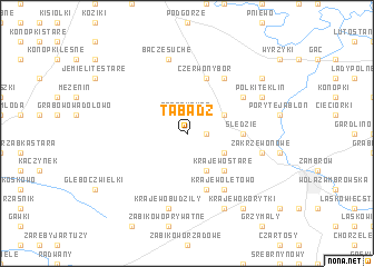
Tabądż (Poland)Tabądż is a town in Poland. An overview map of the region around Tabądż is displayed below.
regional and 3d topo map of Tabądż, Poland ::
Tabądż airports ::
The nearest airport is WAW - Warsaw Okecie, located 123.3 km south west of Tabądż.
Other airports nearby include KGD - Kaliningrad Khrabrovo (231.7 km north west), Nearby towns ::
Bacze Mokre (1.9km north) //
Zagroby Zakrzewo (1.1km east) //
Pstrągi Małe (2.2km north east) //
Pstrągi (2.9km north east) //
Zbrzeźnica (2.9km north east) //
Pstrągi Wielkie (2.9km north east) //
Zakrzewo Stare (2.9km south east) //
Krajewo Borowe (3.9km south) //
Krajewo Cwikły (3.9km south) //
Krajewo Stare (4.3km south east) //
Śledzie (3.3km east) //
Czerwony Bór (5.7km north) //
Modzele Wygoda (5.7km north) //
Krajewo (5.7km south) //
Modzele Skudosze (5.0km north east) //
Modzele Stare (6.0km north) //
Krajewo łętowo (6.0km south) //
Bacze Suche (7.5km north) //
Krajewo Budziły (7.5km south) //
Zakrzewo Nowe (4.8km south east) //
Polki-Teklin (5.8km north east) //
Ostróżne (7.7km south) //
Modzele Wypychy (7.1km north east) //
Krajewo Korytki (8.1km south east) //
[all distances 'as the bird flies' and approximate]  Places with similar names to Tabądż, Poland ::
Disclaimer :: Information on this page comes without warranty of any kind |
||
|
Where is Tabądż? Elevation and coordinates ::
Latitude (lat): 53°1'0"N Longitude (lon): 22°8'0"E
Elevation (approx.): 116m (map arrows pan, magnifying glasses zoom) |
||
|
Visiting Tabądż? Hotel/Accommodation ::
Book a hotel in Tabądż Travel Guide ::
Buy a travel guide for Poland rental cars ::
car rental offers GPS waypoint ::
download a GPX waypoint (PoI) of Tabądż for your GPS receiver
|
||