|
search place name
|
||
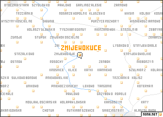
Żmijewo Kuce (Poland)Żmijewo Kuce is a town in Poland. An overview map of the region around Żmijewo Kuce is displayed below.
regional and 3d topo map of Żmijewo Kuce, Poland ::
Żmijewo Kuce airports ::
The nearest airport is WAW - Warsaw Okecie, located 97.4 km south of Żmijewo Kuce.
Other airports nearby include KGD - Kaliningrad Khrabrovo (210.4 km north), Nearby towns ::
Jarluty Małe (2.2km south west) //
Jarluty Duże (2.2km south east) //
Żmijewo Gaje (2.2km west) //
Olszewo Tosie (3.7km north) //
Klice (3.9km south) //
Olszewo Borzymy (3.9km north) //
Żmijewo Pąki (2.9km north west) //
Kątki (3.9km south) //
Zakrzewo Małe (2.9km north east) //
Zakrzewo Wielkie (2.9km north east) //
Zakrzewo (2.9km north east) //
Olszewo Bołąki (4.3km north west) //
Żmijewo Kościelne (4.3km north west) //
Olszewo (4.3km north west) //
Piegłowo (5.6km north) //
Tyszki-Bregendy (5.7km north) //
Konopki (3.8km south west) //
Rosochy (3.8km south west) //
Humiecin Retki (3.8km north east) //
Żeńbok (3.8km south east) //
Krośnice (5.0km south west) //
Karniewo (5.0km south east) //
Olszewo Korzybie (6.0km north) //
Lekowiec (7.5km south) //
Lekowo (7.5km south) //
Pniewo Wielkie (6.5km south west) //
Młodynin Wielki (6.5km north west) //
Jeże (6.5km north west) //
Młodynin Mały (6.5km north west) //
[all distances 'as the bird flies' and approximate]  Places with similar names to Żmijewo Kuce, Poland :: Disclaimer :: Information on this page comes without warranty of any kind |
||
|
Where is Żmijewo Kuce? Elevation and coordinates ::
Latitude (lat): 53°0'0"N Longitude (lon): 20°32'0"E
Elevation (approx.): 126m (map arrows pan, magnifying glasses zoom) |
||
|
Visiting Żmijewo Kuce? Hotel/Accommodation ::
Book a hotel in Żmijewo Kuce Travel Guide ::
Buy a travel guide for Poland rental cars ::
car rental offers GPS waypoint ::
download a GPX waypoint (PoI) of Żmijewo Kuce for your GPS receiver
|
||