|
search place name
|
||
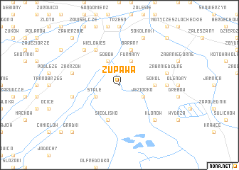
Żupawa (Poland)Żupawa is a town in Poland. An overview map of the region around Żupawa is displayed below.
regional and 3d topo map of Żupawa, Poland ::
Żupawa airports ::
The nearest airport is RZE - Rzeszow Jasionka, located 55.3 km south of Żupawa.
Other airports nearby include KRK - Krakow Balice (153.0 km west), WAW - Warsaw Okecie (185.0 km north), TAT - Poprad Tatry (201.3 km south west), KSC - Kosice (217.1 km south), Nearby towns ::
Stale (3.0km south west) //
Jeziorko (3.0km south east) //
Sobów (3.9km north) //
Furmany (3.9km north) //
Sokół (3.5km east) //
Lisia Góra (3.5km east) //
Siedlisko (5.7km south) //
Barany (5.7km north) //
Wielowieś (6.0km north west) //
Nowiny (4.7km east) //
Mokrzyszów (5.1km west) //
Zakrzów (5.1km west) //
Zabrnie Dolne (5.1km east) //
Sielec (6.6km north west) //
Klonów (6.6km south east) //
Sokolniki (7.8km north) //
Grądki (8.8km south west) //
Koćmierzów (8.8km north west) //
Zawierzbie (8.8km north west) //
Orliska (8.8km north east) //
[all distances 'as the bird flies' and approximate]  Places with similar names to Żupawa, Poland ::
Disclaimer :: Information on this page comes without warranty of any kind |
||
|
Where is Żupawa? Elevation and coordinates ::
Latitude (lat): 50°35'0"N Longitude (lon): 21°47'0"E
Elevation (approx.): 146m (map arrows pan, magnifying glasses zoom) |
||
|
Visiting Żupawa? Hotel/Accommodation ::
Book a hotel in Żupawa Travel Guide ::
Buy a travel guide for Poland rental cars ::
car rental offers GPS waypoint ::
download a GPX waypoint (PoI) of Żupawa for your GPS receiver
|
||