|
search place name
|
||
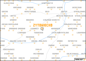
Żytowiecko (Poland)Żytowiecko is a town in Poland. An overview map of the region around Żytowiecko is displayed below.
regional and 3d topo map of Żytowiecko, Poland ::
Żytowiecko airports ::
The nearest airport is POZ - Poznan Lawica, located 67.6 km north of Żytowiecko.
Other airports nearby include WRO - Wroclaw Strachowice (79.5 km south), IEG - Zielona Gora Babimost (85.8 km north west), PED - Pardubice (217.5 km south west), Nearby towns ::
Grodzisko (1.9km north) //
Teodozewo (2.2km south west) //
Łęka Mała (2.3km west) //
Czajkowo (3.9km north) //
Bączylas (4.4km south west) //
Chumiętki (4.4km south east) //
Pudliszki (5.6km south) //
Bukownica (3.4km east) //
Gierłachowo (3.4km west) //
Łęka Wielka (3.9km north west) //
Żychlewo (3.9km south east) //
Karzec (6.0km south) //
Czachorowo (5.1km north east) //
Brzezie Huby (5.1km north east) //
Sikorzyn (5.1km north east) //
Bogdanki (5.1km north west) //
Rokosowo (5.1km south west) //
Gola (7.5km north) //
Kuczyna (7.8km south) //
Zawada (7.8km south) //
Hersztupowo (8.2km north west) //
Krobia (7.2km south east) //
Grabianowo (8.2km south east) //
Brzezie (7.2km north east) //
[all distances 'as the bird flies' and approximate]  Places with similar names to Żytowiecko, Poland ::
Disclaimer :: Information on this page comes without warranty of any kind |
||
|
Where is Żytowiecko? Elevation and coordinates ::
Latitude (lat): 51°49'0"N Longitude (lon): 16°56'0"E
Elevation (approx.): 112m (map arrows pan, magnifying glasses zoom) |
||
|
Visiting Żytowiecko? Hotel/Accommodation ::
Book a hotel in Żytowiecko Travel Guide ::
Buy a travel guide for Poland rental cars ::
car rental offers GPS waypoint ::
download a GPX waypoint (PoI) of Żytowiecko for your GPS receiver
|
||