|
search place name
|
||
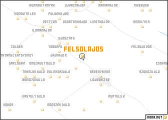
Felsőlajos (Bács-Kiskun, Hungary)Felsőlajos is a town in the Bács-Kiskun region of Hungary. An overview map of the region around Felsőlajos is displayed below.
regional and 3d topo map of Felsőlajos, Hungary ::
Felsőlajos airports ::
The nearest airport is BUD - Budapest Ferihegy, located 45.7 km north west of Felsőlajos.
Other airports nearby include ARW - Arad (166.3 km south east), SLD - Sliac (177.0 km north), OSI - Osijek (186.4 km south), TSR - Timisoara Traian Vuia (197.7 km south east), Nearby towns ::
Közös (2.2km south west) //
Újosztás (4.5km north west) //
Alsóbene (4.5km south east) //
Csurgayújosztás (4.5km north west) //
Újosztás (4.5km north west) //
Berénybene (4.5km south east) //
Hosszúszekidůlő (4.5km south west) //
Jajmajor (3.8km west) //
Táborfalva (4.2km north west) //
Lajosmizse (6.1km south east) //
Csurgaimajor (5.3km north west) //
Gödörállásidůlő (5.3km south west) //
Csíkosdůlő (5.3km south west) //
Jajgatódůlő (5.3km south west) //
Pálinkásdůlő (5.3km south west) //
Ágostonmajor (7.5km north) //
Lipótmajor (7.8km north) //
Ladánybene (6.3km south west) //
Bikahegy (9.0km north west) //
Pettyán (9.0km north west) //
[all distances 'as the bird flies' and approximate]  Places with similar names to Felsőlajos, Hungary :: Disclaimer :: Information on this page comes without warranty of any kind |
||
|
Where is Felsőlajos? Elevation and coordinates ::
Latitude (lat): 47°4'0"N Longitude (lon): 19°31'0"E
Elevation (approx.): 134m (map arrows pan, magnifying glasses zoom) |
||
|
Visiting Felsőlajos? Hotel/Accommodation ::
Book a hotel in Felsőlajos Travel Guide ::
Buy a travel guide for Hungary rental cars ::
car rental offers GPS waypoint ::
download a GPX waypoint (PoI) of Felsőlajos for your GPS receiver
|
||