|
search place name
|
||
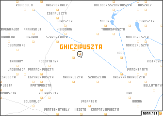
Ghiczipuszta (Komárom-Esztergom, Hungary)Ghiczipuszta is a town in the Komárom-Esztergom region of Hungary. An overview map of the region around Ghiczipuszta is displayed below.
regional and 3d topo map of Ghiczipuszta, Hungary ::
Ghiczipuszta airports ::
The nearest airport is BUD - Budapest Ferihegy, located 86.4 km east of Ghiczipuszta.
Other airports nearby include BTS - Bratislava M R Stefanik (93.6 km north west), PZY - Piestany (116.2 km north), VIE - Vienna Schwechat (130.0 km north west), SLD - Sliac (137.4 km north east), Nearby towns ::
Szőkepuszta (1.2km west) //
Thalypuszta (2.2km north west) //
Makkpuszta (5.7km south) //
Kisigmánd (6.1km north west) //
Baloghtanya (5.3km north west) //
Bódaitanya (5.3km north west) //
Csémi-hegy (5.3km north west) //
Halastó (5.3km north west) //
Nagyigmánd (5.3km north west) //
Szajkótanya (5.3km north west) //
Szarkatanya (5.3km north west) //
Haraszt (6.1km north east) //
Szákszend (6.1km south east) //
Fodortanya (5.3km west) //
Csép (5.3km west) //
Újpuszta (7.8km north) //
Tömördpuszta (7.5km north east) //
Mocsa (8.3km north east) //
[all distances 'as the bird flies' and approximate]  Places with similar names to Ghiczipuszta, Hungary ::
// Fakospuszta (HU)
Disclaimer :: Information on this page comes without warranty of any kind |
||
|
Where is Ghiczipuszta? Elevation and coordinates ::
Latitude (lat): 47°36'0"N Longitude (lon): 18°8'0"E
Elevation (approx.): 142m (map arrows pan, magnifying glasses zoom) |
||
|
Visiting Ghiczipuszta? Hotel/Accommodation ::
Book a hotel in Ghiczipuszta Travel Guide ::
Buy a travel guide for Hungary rental cars ::
car rental offers GPS waypoint ::
download a GPX waypoint (PoI) of Ghiczipuszta for your GPS receiver
|
||