|
search place name
|
||
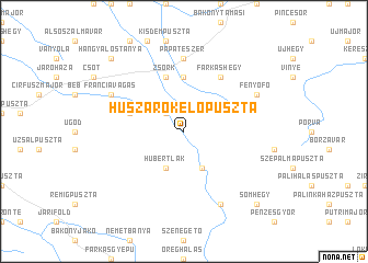
Huszárokelőpuszta (Veszprém, Hungary)Huszárokelőpuszta is a town in the Veszprém region of Hungary. An overview map of the region around Huszárokelőpuszta is displayed below.
regional and 3d topo map of Huszárokelőpuszta, Hungary ::
Huszárokelőpuszta airports ::
The nearest airport is BTS - Bratislava M R Stefanik, located 101.7 km north of Huszárokelőpuszta.
Other airports nearby include BUD - Budapest Ferihegy (118.2 km east), VIE - Vienna Schwechat (122.4 km north west), PZY - Piestany (145.8 km north), SLD - Sliac (181.8 km north east), Nearby towns ::
Bakonykoppány (2.2km north west) //
Bakonyszücs (2.2km north west) //
Hubertlak (3.9km south) //
Gerencepuszta (3.9km south) //
Újmajor (5.6km north) //
Dióspuszta (4.2km north west) //
Zsörk (5.7km north) //
Farkashegy (6.1km north east) //
Fényeshegy (7.4km north) //
Pápateszér (7.4km north) //
Bakonybél (7.8km south) //
Fenyőfő (6.2km north east) //
Franciavágás (6.2km north west) //
Hangyálostanya (9.0km north west) //
Somhegy (9.0km south east) //
[all distances 'as the bird flies' and approximate]  Places with similar names to Huszárokelőpuszta, Hungary :: Disclaimer :: Information on this page comes without warranty of any kind |
||
|
Where is Huszárokelőpuszta? Elevation and coordinates ::
Latitude (lat): 47°19'0"N Longitude (lon): 17°42'0"E
Elevation (approx.): 269m (map arrows pan, magnifying glasses zoom) |
||
|
Visiting Huszárokelőpuszta? Hotel/Accommodation ::
Book a hotel in Huszárokelőpuszta Travel Guide ::
Buy a travel guide for Hungary rental cars ::
car rental offers GPS waypoint ::
download a GPX waypoint (PoI) of Huszárokelőpuszta for your GPS receiver
|
||