|
search place name
|
||
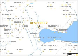
Keszthely (Zala, Hungary)Keszthely is a town in the Zala region of Hungary. An overview map of the region around Keszthely is displayed below.
regional and 3d topo map of Keszthely, Hungary ::
Keszthely airports ::
The nearest airport is MBX - Maribor, located 123.9 km west of Keszthely.
Other airports nearby include GRZ - Graz (140.2 km west), ZAG - Zagreb (145.8 km south west), BTS - Bratislava M R Stefanik (156.1 km north), VIE - Vienna Schwechat (157.9 km north), Nearby towns ::
Kátrányos (0.0km north) //
Goldmarkdůlő (0.0km north) //
Úsztatómajor (0.0km north) //
Tőzegtelep (0.0km north) //
Középsőmalom (0.0km north) //
Kőfejtő (0.0km north) //
Felsőmalom (0.0km north) //
Gyenesdiás (2.5km east) //
Alsómalom (3.9km south) //
Cserszegtomaj (4.5km north west) //
Fenékpuszta (5.6km south) //
Dobogómajor (5.3km north west) //
Alsóvonyarc (5.1km east) //
Alsópáhok (5.1km west) //
Felsővonyarc (5.1km east) //
Hévíz (5.4km west) //
Vonyarcvashegy (5.4km east) //
Négyszögmajor (6.3km north west) //
Sárosgödör (7.5km south east) //
Balatonberény (7.5km south east) //
Vashegy (9.0km north west) //
Karmacs (9.0km north west) //
[all distances 'as the bird flies' and approximate] 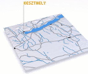 Places with similar names to Keszthely, Hungary :: Disclaimer :: Information on this page comes without warranty of any kind |
||
|
Where is Keszthely? Elevation and coordinates ::
Latitude (lat): 46°46'0"N Longitude (lon): 17°15'0"E
Elevation (approx.): 115m (map arrows pan, magnifying glasses zoom) |
||
|
Visiting Keszthely? Hotel/Accommodation ::
Book a hotel in Keszthely Travel Guide ::
Buy a travel guide for Hungary rental cars ::
car rental offers GPS waypoint ::
download a GPX waypoint (PoI) of Keszthely for your GPS receiver
|
||