|
search place name
|
||
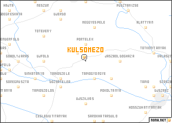
Külsőmező (Pest, Hungary)Külsőmező is a town in the Pest region of Hungary. An overview map of the region around Külsőmező is displayed below.
regional and 3d topo map of Külsőmező, Hungary ::
Külsőmező airports ::
The nearest airport is BUD - Budapest Ferihegy, located 51.8 km west of Külsőmező.
Other airports nearby include DEB - Debrecen (127.6 km east), SLD - Sliac (153.4 km north west), OMR - Oradea (154.0 km east), ARW - Arad (166.7 km south east), Nearby towns ::
Rekettyés (2.2km north west) //
Portelek (3.7km north) //
Békás (3.9km south) //
Kispáskom (3.9km south) //
Kistelek (3.9km south) //
Nagytelek (3.9km south) //
Tápiógyörgye (3.9km south) //
Szomorák (5.3km south west) //
Papszög (5.3km south west) //
Tápiószele (5.3km south west) //
Kismegyer (5.3km south east) //
Jászboldogháza (5.0km east) //
Meggyespele (7.5km north) //
Dózsatelep (6.7km south west) //
Pokoltanya (8.3km south east) //
[all distances 'as the bird flies' and approximate] 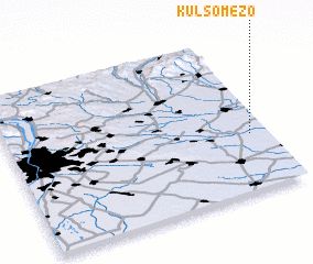
Disclaimer :: Information on this page comes without warranty of any kind |
||
|
Where is Külsőmező? Elevation and coordinates ::
Latitude (lat): 47°22'0"N Longitude (lon): 19°56'0"E
Elevation (approx.): 92m (map arrows pan, magnifying glasses zoom) |
||
|
Visiting Külsőmező? Hotel/Accommodation ::
Book a hotel in Külsőmező Travel Guide ::
Buy a travel guide for Hungary rental cars ::
car rental offers GPS waypoint ::
download a GPX waypoint (PoI) of Külsőmező for your GPS receiver
|
||