|
search place name
|
||
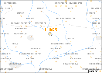
Ludas (Heves, Hungary)Ludas is a town in the Heves region of Hungary. An overview map of the region around Ludas is displayed below.
regional and 3d topo map of Ludas, Hungary ::
Ludas airports ::
The nearest airport is BUD - Budapest Ferihegy, located 71.6 km south west of Ludas.
Other airports nearby include DEB - Debrecen (117.1 km east), SLD - Sliac (123.6 km north west), KSC - Kosice (133.7 km north east), TAT - Poprad Tatry (149.4 km north), Nearby towns ::
Detk (1.9km north) //
Faragótanya (4.5km south east) //
Nagyhármasitanya (4.5km south east) //
Őzsetanya (4.5km north west) //
Halmajugra (4.5km north west) //
Nagyfüged (5.7km south) //
Karácsond (5.0km west) //
Nagyút (5.3km east) //
Olgamajor (6.7km south west) //
Balpüspökipuszta (6.7km north east) //
Kábelház (7.5km north west) //
Brezovaitanya (7.5km north west) //
Visonta (7.5km north west) //
Tarnazsadány (8.9km south east) //
Kenyérvár Úti Tanyák (8.9km south west) //
[all distances 'as the bird flies' and approximate] 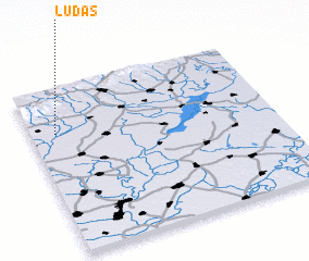 Places with similar names to Ludas, Hungary ::
Disclaimer :: Information on this page comes without warranty of any kind |
||
|
Where is Ludas? Elevation and coordinates ::
Latitude (lat): 47°44'0"N Longitude (lon): 20°6'0"E
Elevation (approx.): 107m (map arrows pan, magnifying glasses zoom) |
||
|
Visiting Ludas? Hotel/Accommodation ::
Book a hotel in Ludas Travel Guide ::
Buy a travel guide for Hungary rental cars ::
car rental offers GPS waypoint ::
download a GPX waypoint (PoI) of Ludas for your GPS receiver
|
||