|
search place name
|
||
Nagypall (Baranya, Hungary)Nagypall is a town in the Baranya region of Hungary. An overview map of the region around Nagypall is displayed below.
regional and 3d topo map of Nagypall, Hungary ::

Nagypall airports ::
The nearest airport is OSI - Osijek, located 81.4 km south of Nagypall.
Other airports nearby include BUD - Budapest Ferihegy (155.7 km north east), BEG - Beograd (207.4 km south east), VIE - Vienna Schwechat (260.5 km north west), Nearby towns ::
Zengővárkony (2.3km north west) //
Pusztakisfalu (2.3km north east) //
Pécsvárad (2.6km west) //
Tóvölgy (3.2km north west) //
Hárommalom (3.2km north west) //
Öregbeke (3.2km north west) //
Kishosszúrét (3.2km north west) //
Külsőtanyák (3.2km north west) //
Lakatosmalom (3.2km north west) //
Szászvölgy (3.2km north west) //
Belsőtanyák (3.2km north west) //
Berekrét (3.2km north west) //
Dobosvölgy (3.2km north west) //
Lovászhetény (3.2km north east) //
Fazekasboda (4.5km south east) //
Apátvarasd (4.5km north east) //
Erzsébet (5.7km south) //
Kékesd (5.7km south) //
Szilágy (6.1km south west) //
Vadászcsárda (6.1km north east) //
Mecseknádasd (7.5km north) //
Vőőmalom (7.5km south) //
Martonfa (6.3km south west) //
Óbánya (7.8km north) //
Erdősmecske (6.3km north east) //
Pereked (7.6km south west) //
[all distances 'as the bird flies' and approximate] 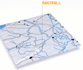
Disclaimer :: Information on this page comes without warranty of any kind |
||
|
Where is Nagypall? Elevation and coordinates ::
Latitude (lat): 46°9'0"N Longitude (lon): 18°27'0"E
Elevation (approx.): 207m (map arrows pan, magnifying glasses zoom) |
||
|
Visiting Nagypall? Hotel/Accommodation ::
Book a hotel in Nagypall Travel Guide ::
Buy a travel guide for Hungary rental cars ::
car rental offers GPS waypoint ::
download a GPX waypoint (PoI) of Nagypall for your GPS receiver
|
||