|
search place name
|
||
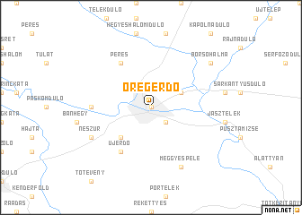
Öregerdő (Jász-Nagykun-Szolnok, Hungary)Öregerdő is a town in the Jász-Nagykun-Szolnok region of Hungary. An overview map of the region around Öregerdő is displayed below.
regional and 3d topo map of Öregerdő, Hungary ::
Öregerdő airports ::
The nearest airport is BUD - Budapest Ferihegy, located 50.3 km west of Öregerdő.
Other airports nearby include DEB - Debrecen (128.0 km east), SLD - Sliac (139.3 km north west), OMR - Oradea (159.3 km east), KSC - Kosice (162.7 km north east), Nearby towns ::
Túlatarna (0.0km north) //
Zsombékos (0.0km north) //
Érpart (0.0km north) //
Felsőmuszáj (0.0km north) //
Jászberény (0.0km north) //
Zagyvapart (0.0km north) //
Rétitanya (2.2km south east) //
Necső (3.1km north east) //
Alsómuszáj (4.5km south west) //
Peres (6.1km north west) //
Újerdő (6.1km south west) //
Pusztakerekudvar (5.0km west) //
Meggyespele (7.8km south) //
Neszůr (6.2km south west) //
Borsóhalma (7.5km north east) //
[all distances 'as the bird flies' and approximate] 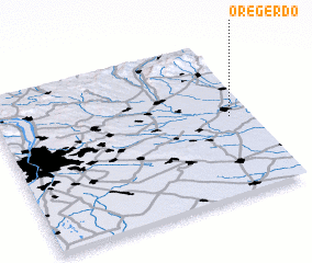
Disclaimer :: Information on this page comes without warranty of any kind |
||
|
Where is Öregerdő? Elevation and coordinates ::
Latitude (lat): 47°30'0"N Longitude (lon): 19°55'0"E
Elevation (approx.): 95m (map arrows pan, magnifying glasses zoom) |
||
|
Visiting Öregerdő? Hotel/Accommodation ::
Book a hotel in Öregerdő Travel Guide ::
Buy a travel guide for Hungary rental cars ::
car rental offers GPS waypoint ::
download a GPX waypoint (PoI) of Öregerdő for your GPS receiver
|
||