|
search place name
|
||
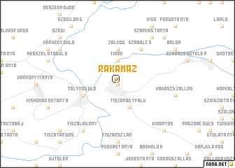
Rakamaz (Szabolcs-Szatmár-Bereg, Hungary)Rakamaz is a town in the Szabolcs-Szatmár-Bereg region of Hungary. An overview map of the region around Rakamaz is displayed below.
regional and 3d topo map of Rakamaz, Hungary ::
Rakamaz airports ::
The nearest airport is KSC - Kosice, located 61.2 km north of Rakamaz.
Other airports nearby include DEB - Debrecen (72.5 km south), SUJ - Satu Mare (116.3 km south east), OMR - Oradea (127.5 km south), TAT - Poprad Tatry (138.2 km north west), Nearby towns ::
Serflektanya (0.0km north) //
Timár (3.7km north) //
Tiszanagyfalu (3.9km south) //
Zalkod (5.6km north) //
Talytódůlő (4.1km south west) //
Hétszőlő (4.1km south west) //
Tokaj (4.1km south west) //
Baksadůlő (4.1km south west) //
Dobódůlő (4.1km south west) //
Szabolcs (6.1km north east) //
Tiszaladány (8.3km south west) //
Reviczkygát (8.3km south west) //
Szarvastanya (8.3km north east) //
Virányos (8.9km south east) //
Kenézlő (8.9km north east) //
Alsótanya (8.9km north east) //
[all distances 'as the bird flies' and approximate] 
Disclaimer :: Information on this page comes without warranty of any kind |
||
|
Where is Rakamaz? Elevation and coordinates ::
Latitude (lat): 48°8'0"N Longitude (lon): 21°28'0"E
Elevation (approx.): 99m (map arrows pan, magnifying glasses zoom) |
||
|
Visiting Rakamaz? Hotel/Accommodation ::
Book a hotel in Rakamaz Travel Guide ::
Buy a travel guide for Hungary rental cars ::
car rental offers GPS waypoint ::
download a GPX waypoint (PoI) of Rakamaz for your GPS receiver
|
||