|
search place name
|
||
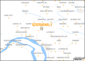
Szendehely (Nógrád, Hungary)Szendehely is a town in the Nógrád region of Hungary. An overview map of the region around Szendehely is displayed below.
regional and 3d topo map of Szendehely, Hungary ::
Szendehely airports ::
The nearest airport is BUD - Budapest Ferihegy, located 47.1 km south of Szendehely.
Other airports nearby include SLD - Sliac (87.6 km north), PZY - Piestany (128.8 km north west), BTS - Bratislava M R Stefanik (146.4 km west), TAT - Poprad Tatry (159.5 km north east), Nearby towns ::
Katalinpuszta (1.2km west) //
Kapáskút (3.7km north) //
Látóhegy (3.1km south east) //
Alsó-Zsukma-erdőőrház (3.1km north east) //
Udvarhelypuszta (3.1km north west) //
Nőtincs (4.5km north east) //
Berkenye (4.5km north west) //
Téglaházpuszta (5.6km south) //
Papsomárka (4.2km south west) //
Zsobrák (5.7km south) //
Dunamező (5.3km south west) //
Magyarkút (5.0km west) //
Zsellérdůlő (7.5km south) //
Csipkés (7.5km south) //
Kőhíd (7.5km south) //
Középmáj (7.5km south) //
Kútvölgy (7.5km south) //
Mihálytanya (7.5km south) //
Patakföld (7.5km south) //
Pusztaszántó (7.5km north) //
Vác (7.5km south) //
Csatadůlő (7.5km south) //
Derecskedůlő (7.5km south) //
Fenyvesdůlő (7.5km south) //
Magyarmál (5.3km west) //
Cselőtepuszta (6.7km south east) //
Kőszénbányatelep (6.2km south east) //
Kosd (7.5km south east) //
Nógrád (8.9km north west) //
[all distances 'as the bird flies' and approximate] 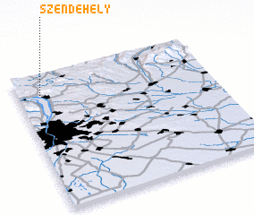 Places with similar names to Szendehely, Hungary :: Disclaimer :: Information on this page comes without warranty of any kind |
||
|
Where is Szendehely? Elevation and coordinates ::
Latitude (lat): 47°51'0"N Longitude (lon): 19°7'0"E
Elevation (approx.): 215m (map arrows pan, magnifying glasses zoom) |
||
|
Visiting Szendehely? Hotel/Accommodation ::
Book a hotel in Szendehely Travel Guide ::
Buy a travel guide for Hungary rental cars ::
car rental offers GPS waypoint ::
download a GPX waypoint (PoI) of Szendehely for your GPS receiver
|
||