|
search place name
|
||
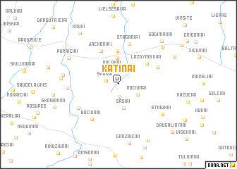
Katinai (Lithuania)Katinai is a town in Lithuania. An overview map of the region around Katinai is displayed below.
regional and 3d topo map of Katinai, Lithuania ::
Nearby towns ::
Darginiai (2.0km south) //
Skakai (1.2km north west) //
Valakai (2.4km north) //
Nociūnai (2.4km south east) //
Šašiai (3.8km south) //
Kriukai (4.2km north) //
Dvareliškiai (5.3km north) //
Lazdyniškiai (4.1km north east) //
Jackoniai (5.5km north) //
Stagariai (6.5km north) //
Lieporai (4.4km north east) //
Bučiūnai (6.0km south west) //
Mišeikiai (5.1km south west) //
Skutenos (4.5km west) //
Striukai (6.2km south east) //
Pavirčiuvė (5.1km west) //
Pūraičiai (6.0km north west) //
Mažėliai (7.0km north east) //
Sodininkai (7.9km north east) //
Giedraičiai (9.3km south) //
(( Ķauķi )) (8.7km north west) //
Daugalioniai (8.9km south east) //
[all distances 'as the bird flies' and approximate]  Places with similar names to Katinai, Lithuania ::
Disclaimer :: Information on this page comes without warranty of any kind |
||
|
Where is Katinai? Elevation and coordinates ::
Latitude (lat): 56°15'39"N Longitude (lon): 23°49'18"E
Elevation (approx.): 47m (map arrows pan, magnifying glasses zoom) |
||
|
Visiting Katinai? Hotel/Accommodation ::
Book a hotel in Katinai Travel Guide ::
Buy a travel guide for Lithuania rental cars ::
car rental offers GPS waypoint ::
download a GPX waypoint (PoI) of Katinai for your GPS receiver
|
||