|
search place name
|
||
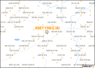
Martynaičiai (Lithuania)Martynaičiai is a town in Lithuania. An overview map of the region around Martynaičiai is displayed below.
regional and 3d topo map of Martynaičiai, Lithuania ::
Nearby towns ::
Bargailiai I (2.1km north west) //
Vedreikiai (2.1km east) //
Levikainiai Aukštieji (2.1km west) //
Vosiliškis (3.7km south) //
Aukštuoliai (2.8km south west) //
Gulbinai (3.9km north) //
Giedraičiai (3.9km north) //
Valatkaičiukai (3.7km south west) //
Bargailiai II (3.7km north west) //
Meiliškiai (5.7km south) //
Mikailiškiai (5.9km north) //
Kalančiai (7.4km north) //
Barsukynė (7.5km south) //
Trankiniai (7.5km south) //
Pašušvys (6.4km north east) //
Dirgaičiai (6.4km south east) //
Pašušvys (7.7km north) //
Valatkaičiai (5.6km south west) //
Sokmedžiai (8.5km north west) //
[all distances 'as the bird flies' and approximate]  Places with similar names to Martynaičiai, Lithuania ::
// Martynaičiai (LT)
// Martonosha (UA)
// Martan-Chu (RU)
// Mertensia (US)
// Moraedunch'i (KP)
// (( Martanesh )) (AL)
// Martinésia (BR)
Disclaimer :: Information on this page comes without warranty of any kind |
||
|
Where is Martynaičiai? Elevation and coordinates ::
Latitude (lat): 55°32'0"N Longitude (lon): 23°33'0"E
Elevation (approx.): 117m (map arrows pan, magnifying glasses zoom) |
||
|
Visiting Martynaičiai? Hotel/Accommodation ::
Book a hotel in Martynaičiai Travel Guide ::
Buy a travel guide for Lithuania rental cars ::
car rental offers GPS waypoint ::
download a GPX waypoint (PoI) of Martynaičiai for your GPS receiver
|
||