|
search place name
|
||
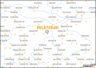
Peletkojai (Lithuania)Peletkojai is a town in Lithuania. An overview map of the region around Peletkojai is displayed below.
regional and 3d topo map of Peletkojai, Lithuania ::
Nearby towns ::
Varmės (1.0km west) //
Užvarmis (1.0km west) //
Čekaičiai (2.1km north west) //
Gedužiai (3.9km south) //
Čiotiškiai (4.3km north west) //
Daugėnai (3.1km west) //
Vabaliai (3.1km east) //
Ušnėnai (5.7km north) //
Cedroniškė (5.7km north) //
Dubenai (3.6km south east) //
Užgiriai (5.7km south) //
Ušakiai (5.9km north) //
Bagužiai (5.9km south) //
Lipšiai (5.9km south) //
Paprūdžiai (5.9km south) //
Kūjokai (4.9km south east) //
Vaiguva (6.9km south) //
Lykšilis (4.2km east) //
Pagančiukai (4.6km north east) //
Pakupelkis (5.6km north east) //
Klapatai (7.7km south) //
Judikiai (8.0km south east) //
Toleikiai (8.5km north east) //
[all distances 'as the bird flies' and approximate]  Places with similar names to Peletkojai, Lithuania ::
// Palo de Caja (DO)
Disclaimer :: Information on this page comes without warranty of any kind |
||
|
Where is Peletkojai? Elevation and coordinates ::
Latitude (lat): 55°46'0"N Longitude (lon): 22°45'0"E
Elevation (approx.): 103m (map arrows pan, magnifying glasses zoom) |
||
|
Visiting Peletkojai? Hotel/Accommodation ::
Book a hotel in Peletkojai Travel Guide ::
Buy a travel guide for Lithuania rental cars ::
car rental offers GPS waypoint ::
download a GPX waypoint (PoI) of Peletkojai for your GPS receiver
|
||