|
search place name
|
||
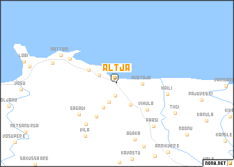
Altja (Lääne-Virumaa, Estonia)Altja is a town in the Lääne-Virumaa region of Estonia. An overview map of the region around Altja is displayed below.
regional and 3d topo map of Altja, Estonia ::
Altja airports ::
The nearest airport is TLL - Tallinn-ulemiste International Tallinn, located 74.9 km west of Altja.
Other airports nearby include HEM - Helsinki Malmi (96.0 km north west), HEL - Helsinki Vantaa (104.2 km north west), QVY - Utti (153.5 km north), Nearby towns ::
Oandu (2.0km south) //
Vergi (2.0km north west) //
Tepelvälja (3.1km south) //
Loisu (3.6km south) //
Mustoja (2.1km east) //
Lauli (4.0km south) //
Pihlaspea (3.2km north west) //
Sagadi (5.5km south) //
Vihula (4.8km south east) //
Sagadi (5.9km south west) //
Kakuvälja (7.0km south) //
Haili (4.4km south east) //
Pedassaare (5.5km north west) //
Paasi (7.5km south east) //
Vila (8.8km south) //
[all distances 'as the bird flies' and approximate]  Places with similar names to Altja, Estonia ::
// Aldige (ES)
// Alitaje (ES)
// Aladji (CF)
// Ali Ouidja (CF)
// Aladje (NG)
// Alate Iju (NG)
// Al ‘Atāʼij (IQ)
// Alédji (TG)
// Aalidji (SY)
// Aldjé (TD)
Disclaimer :: Information on this page comes without warranty of any kind |
||
|
Where is Altja? Elevation and coordinates ::
Latitude (lat): 59°34'51"N Longitude (lon): 26°6'48"E
Elevation (approx.): 28m (map arrows pan, magnifying glasses zoom) |
||
|
Visiting Altja? Hotel/Accommodation ::
Book a hotel in Altja Travel Guide ::
Buy a travel guide for Estonia rental cars ::
car rental offers GPS waypoint ::
download a GPX waypoint (PoI) of Altja for your GPS receiver
|
||