|
search place name
|
||
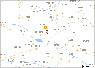
Kivi (Viljandimaa, Estonia)Kivi is a town in the Viljandimaa region of Estonia. An overview map of the region around Kivi is displayed below.
regional and 3d topo map of Kivi, Estonia ::
Kivi airports ::
The nearest airport is TLL - Tallinn-ulemiste International Tallinn, located 137.8 km north of Kivi.
Nearby towns ::
Mõõnaste (1.5km west) //
Päidre (2.6km north) //
Sultsi (2.1km east) //
Õisu (4.0km south) //
Kalvre (5.5km south) //
Loodi (5.6km north) //
Musta (5.9km south) //
Ereste (5.0km south west) //
Hendrikumõisa (6.0km north) //
Aidu (4.1km north east) //
Ülemõisa (6.3km south) //
Ramsi (8.1km north) //
Matapera (7.7km north) //
Sinialliku (8.2km north) //
Tiri (8.7km south) //
Muri (6.4km south east) //
Vardi (8.0km north) //
Paistu (5.9km north east) //
Lageduse (5.5km north east) //
Intsu (7.6km north east) //
Naba (6.8km north west) //
Toosi (7.6km south west) //
Kaarli (6.8km south west) //
Morna (9.2km south) //
[all distances 'as the bird flies' and approximate] 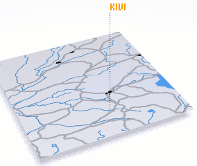 Places with similar names to Kivi, Estonia ::
Disclaimer :: Information on this page comes without warranty of any kind |
||
|
Where is Kivi? Elevation and coordinates ::
Latitude (lat): 58°14'0"N Longitude (lon): 25°33'0"E
Elevation (approx.): 85m (map arrows pan, magnifying glasses zoom) |
||
|
Visiting Kivi? Hotel/Accommodation ::
Book a hotel in Kivi Travel Guide ::
Buy a travel guide for Estonia rental cars ::
car rental offers GPS waypoint ::
download a GPX waypoint (PoI) of Kivi for your GPS receiver
|
||