|
search place name
|
||
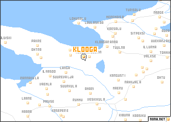
Klooga (Harjumaa, Estonia)Klooga is a town in the Harjumaa region of Estonia. An overview map of the region around Klooga is displayed below.
regional and 3d topo map of Klooga, Estonia ::
Klooga airports ::
The nearest airport is TLL - Tallinn-ulemiste International Tallinn, located 36.8 km east of Klooga.
Other airports nearby include HEM - Helsinki Malmi (114.1 km north east), HEL - Helsinki Vantaa (118.9 km north), TKU - Turku (172.0 km north west), Nearby towns ::
Klooga Aedlinn (1.0km north east) //
Põllküla (2.1km north west) //
Kersalu (2.9km north west) //
Langa (3.4km south west) //
Kloogaranna (4.0km north east) //
Suurevalja (5.1km south west) //
Ämari (7.2km south) //
Suurküla (6.7km south) //
Laulasmaa (7.5km north) //
Tuulna (4.3km north east) //
Ahtma (6.2km north east) //
Kangusti (5.5km south east) //
Lohusalu (8.3km north) //
Ilmasoo (5.2km south west) //
Käesalu (6.9km north east) //
Maeru (7.9km south east) //
Väemla (7.5km south west) //
Meremõisa (9.3km north) //
Karilepa (8.5km south west) //
Vasalemma (9.5km south east) //
[all distances 'as the bird flies' and approximate] 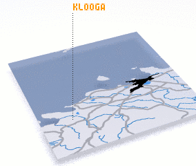 Places with similar names to Klooga, Estonia ::
Disclaimer :: Information on this page comes without warranty of any kind |
||
|
Where is Klooga? Elevation and coordinates ::
Latitude (lat): 59°19'11"N Longitude (lon): 24°12'41"E
Elevation (approx.): 21m (map arrows pan, magnifying glasses zoom) |
||
|
Visiting Klooga? Hotel/Accommodation ::
Book a hotel in Klooga Travel Guide ::
Buy a travel guide for Estonia rental cars ::
car rental offers GPS waypoint ::
download a GPX waypoint (PoI) of Klooga for your GPS receiver
|
||