|
search place name
|
||
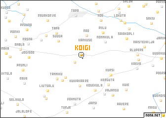
Koigi (Järvamaa, Estonia)Koigi is a town in the Järvamaa region of Estonia. An overview map of the region around Koigi is displayed below.
regional and 3d topo map of Koigi, Estonia ::
Koigi airports ::
The nearest airport is TLL - Tallinn-ulemiste International Tallinn, located 70.3 km north west of Koigi.
Other airports nearby include HEM - Helsinki Malmi (131.5 km north west), HEL - Helsinki Vantaa (139.7 km north west), QVY - Utti (199.5 km north), Nearby towns ::
Reinevere (1.2km south west) //
Karkuse (3.2km north) //
Näo (5.4km north) //
Kaarevere (4.7km south west) //
Kuivakaare (6.1km south) //
Nõmmküla (4.6km north east) //
Roosna (5.4km south west) //
Suuga (4.9km north west) //
Kursi (4.9km south east) //
Tammiku (5.4km south west) //
Piilu (6.4km north) //
Kõdeküla (7.3km south) //
Kerguta (6.5km south east) //
Tapa (6.7km north west) //
Piiri (8.3km south) //
Moe (9.0km north) //
Jootme (6.8km north west) //
Vajangu (8.9km south east) //
Liutsalu (8.2km south west) //
Rauakõrve (9.7km north west) //
Paistevälja (9.6km south west) //
Lokuta (9.8km north east) //
[all distances 'as the bird flies' and approximate] 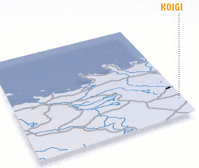 Places with similar names to Koigi, Estonia ::
Disclaimer :: Information on this page comes without warranty of any kind |
||
|
Where is Koigi? Elevation and coordinates ::
Latitude (lat): 59°10'18"N Longitude (lon): 25°58'23"E
Elevation (approx.): 122m (map arrows pan, magnifying glasses zoom) |
||
|
Visiting Koigi? Hotel/Accommodation ::
Book a hotel in Koigi Travel Guide ::
Buy a travel guide for Estonia rental cars ::
car rental offers GPS waypoint ::
download a GPX waypoint (PoI) of Koigi for your GPS receiver
|
||