|
search place name
|
||
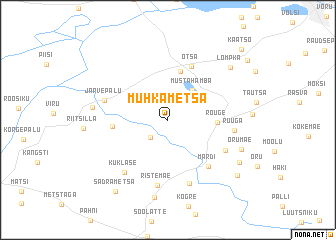
Muhkametsa (Võrumaa, Estonia)Muhkametsa is a town in the Võrumaa region of Estonia. An overview map of the region around Muhkametsa is displayed below.
regional and 3d topo map of Muhkametsa, Estonia ::
Nearby towns ::
Hurda (2.2km south west) //
Lauri (2.8km north) //
Mustahamba (3.6km north east) //
Rõuge (3.0km east) //
Nursi (5.5km north) //
Kaugu (3.4km west) //
Otsa (6.1km north) //
Märdi (5.8km south east) //
Heibri (4.9km south east) //
Ristemäe (7.4km south) //
Ruuga (4.1km east) //
Järvepalu (4.4km north west) //
Pärlijõe (7.3km south) //
Kuklase (6.4km south west) //
Sänna (4.7km west) //
Listaku (8.7km south) //
Orumäe (5.5km south east) //
Lompka (6.9km north east) //
Viitina (6.4km south east) //
Sadrametsa (8.6km south) //
Kaveldi (7.5km south east) //
Vana-Nursi (8.2km north east) //
Käätso (9.0km north east) //
[all distances 'as the bird flies' and approximate]  Places with similar names to Muhkametsa, Estonia ::
Disclaimer :: Information on this page comes without warranty of any kind |
||
|
Where is Muhkametsa? Elevation and coordinates ::
Latitude (lat): 57°43'48"N Longitude (lon): 26°51'36"E
Elevation (approx.): 149m (map arrows pan, magnifying glasses zoom) |
||
|
Visiting Muhkametsa? Hotel/Accommodation ::
Book a hotel in Muhkametsa Travel Guide ::
Buy a travel guide for Estonia rental cars ::
car rental offers GPS waypoint ::
download a GPX waypoint (PoI) of Muhkametsa for your GPS receiver
|
||