|
search place name
|
||
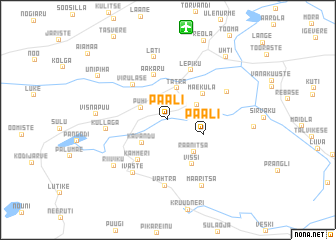
Paali (Tartumaa, Estonia)Paali is a town in the Tartumaa region of Estonia. An overview map of the region around Paali is displayed below.
regional and 3d topo map of Paali, Estonia ::
Paali airports ::
The nearest airport is TLL - Tallinn-ulemiste International Tallinn, located 170.5 km north west of Paali.
Nearby towns ::
Pühi (2.1km north west) //
Kambja (2.4km north east) //
Tatra (3.6km north) //
Kavandu (3.0km south west) //
Suure-Kambja (2.1km east) //
Paali (2.6km south east) //
Raanitsa (3.9km south east) //
Mäeküla (3.5km north east) //
Aakaru (5.0km north) //
Virulase (4.4km north west) //
Kammeri (4.8km south) //
Vissi (5.1km south) //
Lepiku (5.7km north) //
Kullaga (3.8km west) //
Ivaste (6.2km south) //
Läti (7.0km north) //
Madise (4.6km north east) //
Vahtra (7.3km south) //
Riiviku (6.0km south west) //
Visnapuu (4.3km west) //
Maaritsa (7.6km south) //
Unipiha (6.4km north west) //
Uhti (7.8km north east) //
Reola (9.1km north) //
[all distances 'as the bird flies' and approximate] 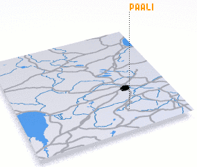 Places with similar names to Paali, Estonia ::
Disclaimer :: Information on this page comes without warranty of any kind |
||
|
Where is Paali? Elevation and coordinates ::
Latitude (lat): 58°12'56"N Longitude (lon): 26°40'17"E
Elevation (approx.): 85m (map arrows pan, magnifying glasses zoom) |
||
|
Visiting Paali? Hotel/Accommodation ::
Book a hotel in Paali Travel Guide ::
Buy a travel guide for Estonia rental cars ::
car rental offers GPS waypoint ::
download a GPX waypoint (PoI) of Paali for your GPS receiver
|
||