|
search place name
|
||
Tagala (Saaremaa, Estonia)Tagala is a town in the Saaremaa region of Estonia. An overview map of the region around Tagala is displayed below.
regional and 3d topo map of Tagala, Estonia ::
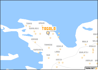
Nearby towns ::
Lätiniidi (0.8km north) //
Sepise (1.1km south) //
Vaigu (0.9km north east) //
Kalmu (1.8km west) //
Veere (2.0km east) //
Ranna (2.1km east) //
Undva (3.7km north) //
Tammese (4.8km south) //
Metsaküla (2.8km west) //
Kuralase (3.3km north west) //
Kõruse (3.9km south west) //
Kehila (5.8km south east) //
Kurevere (7.0km south) //
Tohku (5.1km north west) //
Läägi (7.8km south) //
Oju (8.7km south) //
Neeme (5.8km north west) //
[all distances 'as the bird flies' and approximate] 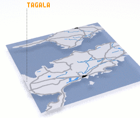 Places with similar names to Tagala, Estonia ::
Disclaimer :: Information on this page comes without warranty of any kind |
||
|
Where is Tagala? Elevation and coordinates ::
Latitude (lat): 58°27'43"N Longitude (lon): 22°1'13"E
Elevation (approx.): 24m (map arrows pan, magnifying glasses zoom) |
||
|
Visiting Tagala? Hotel/Accommodation ::
Book a hotel in Tagala Travel Guide ::
Buy a travel guide for Estonia rental cars ::
car rental offers GPS waypoint ::
download a GPX waypoint (PoI) of Tagala for your GPS receiver
|
||