|
search place name
|
||
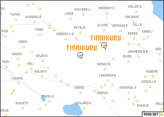
Tinnikuru (Viljandimaa, Estonia)Tinnikuru is a town in the Viljandimaa region of Estonia. An overview map of the region around Tinnikuru is displayed below.
regional and 3d topo map of Tinnikuru, Estonia ::
Tinnikuru airports ::
The nearest airport is TLL - Tallinn-ulemiste International Tallinn, located 145.3 km north of Tinnikuru.
Nearby towns ::
Vilimeeste (4.5km north) //
Paluküla (4.8km north) //
Kuressaare (4.3km north east) //
Ämmuste (3.6km south east) //
Tinnikuru (3.5km north east) //
Raassilla (5.0km north west) //
Metsla (6.0km north) //
Anikatsi (6.3km south) //
Kuressaare (3.7km east) //
Muksi (5.8km south west) //
Aruküla (5.0km south west) //
Kannuküla (7.4km south) //
Kannu (7.8km south) //
Tagamõisa (5.9km south east) //
Kärstna (6.9km south) //
Veski (6.5km south east) //
Koidu (5.7km north east) //
Pahuvere (4.6km south west) //
Ülensi (7.0km north) //
Karuli (8.0km south) //
Pulleritsu (7.3km north west) //
Murru (7.0km south east) //
Lepiku (8.1km north west) //
Holstre (8.7km north west) //
Vanausse (7.9km north east) //
[all distances 'as the bird flies' and approximate]  Places with similar names to Tinnikuru, Estonia ::
Disclaimer :: Information on this page comes without warranty of any kind |
||
|
Where is Tinnikuru? Elevation and coordinates ::
Latitude (lat): 58°12'12"N Longitude (lon): 25°46'13"E
Elevation (approx.): 80m (map arrows pan, magnifying glasses zoom) |
||
|
Visiting Tinnikuru? Hotel/Accommodation ::
Book a hotel in Tinnikuru Travel Guide ::
Buy a travel guide for Estonia rental cars ::
car rental offers GPS waypoint ::
download a GPX waypoint (PoI) of Tinnikuru for your GPS receiver
|
||