|
search place name
|
||
Uuta (Tartumaa, Estonia)Uuta is a town in the Tartumaa region of Estonia. An overview map of the region around Uuta is displayed below.
regional and 3d topo map of Uuta, Estonia ::

Uuta airports ::
The nearest airport is TLL - Tallinn-ulemiste International Tallinn, located 162.2 km north west of Uuta.
Nearby towns ::
Illi (1.5km south) //
Peedu (1.9km north) //
Elva (1.2km west) //
Altmäe (1.6km east) //
Käärdi (2.2km south west) //
Vissi (4.0km north) //
Tamsa (2.6km east) //
Viisjaagu (5.3km north) //
Sassi (5.3km south) //
Ketneri (5.7km south) //
Tõravere (5.7km north) //
Etsaste (4.3km south east) //
Ennu (3.5km east) //
Vellavere (4.9km north west) //
Laguja (6.4km south) //
Metsalaane (4.3km north west) //
Voika (5.2km north east) //
Kurelaane (3.9km west) //
Kääni (6.3km south east) //
Käo (4.2km west) //
Meeri (8.0km north) //
Külaaseme (8.1km north) //
Pastaku (7.9km south west) //
Mäelooga (8.7km south west) //
Uderna (7.2km south west) //
[all distances 'as the bird flies' and approximate] 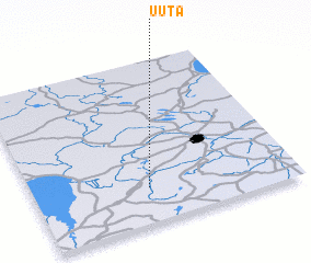 Places with similar names to Uuta, Estonia ::
Disclaimer :: Information on this page comes without warranty of any kind |
||
|
Where is Uuta? Elevation and coordinates ::
Latitude (lat): 58°13'10"N Longitude (lon): 26°26'28"E
Elevation (approx.): 55m (map arrows pan, magnifying glasses zoom) |
||
|
Visiting Uuta? Hotel/Accommodation ::
Book a hotel in Uuta Travel Guide ::
Buy a travel guide for Estonia rental cars ::
car rental offers GPS waypoint ::
download a GPX waypoint (PoI) of Uuta for your GPS receiver
|
||