|
search place name
|
||
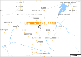
Loynaz Hechevarría (Holguín, Cuba)Loynaz Hechevarría is a town in the Holguín region of Cuba. An overview map of the region around Loynaz Hechevarría is displayed below.
regional and 3d topo map of Loynaz Hechevarría, Cuba ::
Loynaz Hechevarría airports ::
The nearest airport is HOG - Holguin Frank Pais Intl, located 45.1 km north west of Loynaz Hechevarría.
Other airports nearby include SCU - Santiago De Cuba Antonio Maceo Intl (67.2 km south), BYM - Bayamo Carlos Manuel De Cespedes (72.5 km west), GAO - Guantanamo Mariana Grajales (98.4 km south east), MOA - Moa Orestes Acosta (107.6 km east), Nearby towns ::
Arango (2.5km south west) //
Benito (3.7km north) //
La Güira (4.1km north west) //
Birán (3.9km south east) //
Paula (5.6km north) //
Barajagua La Vieja (5.5km west) //
Alto Cedro (5.8km south) //
Barajagua (6.6km north west) //
Ferrando (6.4km south west) //
Jagüeyes (7.4km north) //
Varona (7.4km south) //
El Corojo (7.6km north) //
Colás (7.2km west) //
Sabanilla de Biráo (7.6km south east) //
Segrego Almeida (8.2km south west) //
Cueto (8.7km north) //
[all distances 'as the bird flies' and approximate] 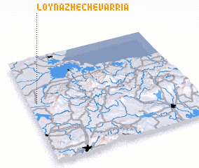 Places with similar names to Loynaz Hechevarría, Cuba :: Disclaimer :: Information on this page comes without warranty of any kind |
||
|
Where is Loynaz Hechevarría? Elevation and coordinates ::
Latitude (lat): 20°34'0"N Longitude (lon): 75°57'0"W
Elevation (approx.): 87m (map arrows pan, magnifying glasses zoom) |
||
|
Visiting Loynaz Hechevarría? Hotel/Accommodation ::
Book a hotel in Loynaz Hechevarría Travel Guide ::
Buy a travel guide for Cuba rental cars ::
car rental offers GPS waypoint ::
download a GPX waypoint (PoI) of Loynaz Hechevarría for your GPS receiver
|
||