|
search place name
|
||
Pontezuela (Camagüey, Cuba)Pontezuela is a town in the Camagüey region of Cuba. An overview map of the region around Pontezuela is displayed below.
regional and 3d topo map of Pontezuela, Cuba ::

Pontezuela airports ::
The nearest airport is CMW - Camaguey Ignacio Agramonte Intl, located 25.2 km south east of Pontezuela.
Other airports nearby include AVI - Ciego De Avila Maximo Gomez (93.8 km north west), VTU - Las Tunas Hermanos Ameijeiras (130.1 km south east), MZO - Manzanillo Sierra Maestra (172.8 km south east), BYM - Bayamo Carlos Manuel De Cespedes (195.7 km south east), Nearby towns ::
Heredia (2.3km east) //
Sabana Nueva (3.9km south west) //
Yaraguanal (5.8km north) //
Santa Rosa del Barranco (6.5km north west) //
Caonao (9.1km south) //
Las Parras (10.6km south west) //
El Guano (11.1km south east) //
[all distances 'as the bird flies' and approximate] 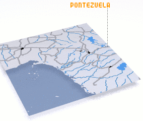 Places with similar names to Pontezuela, Cuba ::
// Ponticelli (IT)
// Ponticelli (IT)
// Ponticelli (IT)
// Ponticelli (IT)
// Ponticelli (IT)
// Ponticiella (ES)
// Puenteciella (ES)
// Pandisili (BF)
// Pontezuela (CO)
// Pontezuela (GT)
Disclaimer :: Information on this page comes without warranty of any kind |
||
|
Where is Pontezuela? Elevation and coordinates ::
Latitude (lat): 21°35'0"N Longitude (lon): 78°1'0"W
Elevation (approx.): 84m (map arrows pan, magnifying glasses zoom) |
||
|
Visiting Pontezuela? Hotel/Accommodation ::
Book a hotel in Pontezuela Travel Guide ::
Buy a travel guide for Cuba rental cars ::
car rental offers GPS waypoint ::
download a GPX waypoint (PoI) of Pontezuela for your GPS receiver
|
||