|
search place name
|
||
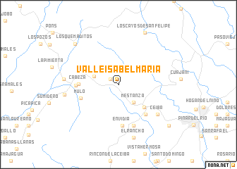
Valle Isabel María (Pinar del Río, Cuba)Valle Isabel María is a town in the Pinar del Río region of Cuba. An overview map of the region around Valle Isabel María is displayed below.
regional and 3d topo map of Valle Isabel María, Cuba ::
Valle Isabel María airports ::
The nearest airport is LCL - La Coloma, located 22.8 km south east of Valle Isabel María.
Other airports nearby include GER - Nueva Gerona Rafael Cabrera (127.0 km south east), HAV - Havana Jose Marti Intl (154.3 km east), Nearby towns ::
Moncada (1.5km north west) //
Mestanza (3.6km south east) //
Isabel María (3.8km west) //
El Cangre (5.2km south east) //
Cabeza (5.9km west) //
Piedra (6.1km south east) //
Mulo (6.0km west) //
Envidia (6.6km south) //
Puente de Cabezas (6.3km west) //
El Guayabo (6.9km south) //
Palmarito (7.4km south east) //
Los Mangos (7.4km south east) //
Ceiba (7.4km south east) //
Coloradas (8.0km west) //
Palo Blanco (8.1km west) //
El Rancho (8.7km south) //
Los Cayos de San Felipe (9.1km north east) //
Los Quemaditos (9.0km north west) //
Cana Alta (9.9km south east) //
[all distances 'as the bird flies' and approximate] 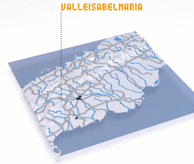 Places with similar names to Valle Isabel María, Cuba :: Disclaimer :: Information on this page comes without warranty of any kind |
||
|
Where is Valle Isabel María? Elevation and coordinates ::
Latitude (lat): 22°28'32"N Longitude (lon): 83°48'19"W
Elevation (approx.): 242m (map arrows pan, magnifying glasses zoom) |
||
|
Visiting Valle Isabel María? Hotel/Accommodation ::
Book a hotel in Valle Isabel María Travel Guide ::
Buy a travel guide for Cuba rental cars ::
car rental offers GPS waypoint ::
download a GPX waypoint (PoI) of Valle Isabel María for your GPS receiver
|
||