|
search place name
|
||
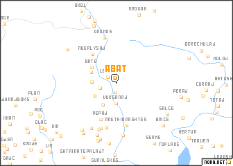
Abat (Shkodër, Albania)Abat is a town in the Shkodër region of Albania. An overview map of the region around Abat is displayed below.
regional and 3d topo map of Abat, Albania ::
Abat airports ::
The nearest airport is TGD - Podgorica, located 46.1 km west of Abat.
Other airports nearby include TIV - Tivat (89.9 km west), TIA - Tirana Rinas (100.0 km south), PRN - Pristina (105.1 km east), DBV - Dubrovnik (129.7 km west), Nearby towns ::
Nicaj-Shalë (1.5km south) //
Lekaj (1.5km north west) //
Nënmavriq (2.2km west) //
Vuksanaj (3.3km south) //
Gimaj (3.0km west) //
Dakaj (3.3km south west) //
Lotaj (3.8km south west) //
Gagu (3.5km north west) //
Batë (3.8km north west) //
Ndërlysaj (5.5km north west) //
Pepaj (6.1km south) //
Rreth i Brashtës (6.9km south) //
Ndrejaj (7.2km south) //
Grumas (7.4km north) //
Mekshaj (7.4km south) //
Celaj (7.7km south) //
Gurrë (7.8km south west) //
Brashtë (8.3km south) //
Shoshit (8.6km south) //
Nicaj-Shosh (8.6km south west) //
Salcë (7.8km south east) //
Kaprejë (8.0km north west) //
Qilikok (8.9km south west) //
Bricë (8.8km south east) //
[all distances 'as the bird flies' and approximate]  Places with similar names to Abat, Albania ::
Disclaimer :: Information on this page comes without warranty of any kind |
||
|
Where is Abat? Elevation and coordinates ::
Latitude (lat): 42°18'45"N Longitude (lon): 19°48'28"E
Elevation (approx.): 722m (map arrows pan, magnifying glasses zoom) |
||
|
Visiting Abat? Hotel/Accommodation ::
Book a hotel in Abat Travel Guide ::
Buy a travel guide for Albania rental cars ::
car rental offers GPS waypoint ::
download a GPX waypoint (PoI) of Abat for your GPS receiver
|
||