|
search place name
|
||
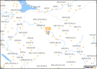
Vig (Shkodër, Albania)Vig is a town in the Shkodër region of Albania. An overview map of the region around Vig is displayed below.
regional and 3d topo map of Vig, Albania ::
Vig airports ::
The nearest airport is TIA - Tirana Rinas, located 57.5 km south of Vig.
Other airports nearby include TGD - Podgorica (62.0 km north west), TIV - Tivat (98.7 km north west), OHD - Ohrid (118.5 km south east), PRN - Pristina (128.7 km north east), Nearby towns ::
Kastra e Poshtëme (1.2km south east) //
Fushë Vigu (1.9km north west) //
Kalivaç (2.6km south east) //
(( Rasboks )) (3.3km north west) //
Zimaj (3.1km south east) //
Gjobardhaj (3.4km east) //
Kaftallë (3.9km north east) //
Rrasi i Butë (4.6km south east) //
Mnela e Vogël (5.4km north west) //
(( Turrec )) (5.0km east) //
Mnela e Madhe (6.1km north west) //
Krajn (5.6km south west) //
Fishtë (6.8km south west) //
Fregën (8.4km south) //
Mirdicë (8.7km north) //
Gomsiqe (7.6km north east) //
Korthpulë (7.0km north east) //
Kashnjet (6.9km east) //
Troshan (7.9km south west) //
Ungrej (8.0km south east) //
Kallmeti i Vogël (8.8km south) //
Sherilaj (10.6km south east) //
[all distances 'as the bird flies' and approximate] 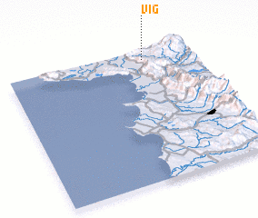 Places with similar names to Vig, Albania ::
Disclaimer :: Information on this page comes without warranty of any kind |
||
|
Where is Vig? Elevation and coordinates ::
Latitude (lat): 41°55'57"N Longitude (lon): 19°44'8"E
Elevation (approx.): 145m (map arrows pan, magnifying glasses zoom) |
||
|
Visiting Vig? Hotel/Accommodation ::
Book a hotel in Vig Travel Guide ::
Buy a travel guide for Albania rental cars ::
car rental offers GPS waypoint ::
download a GPX waypoint (PoI) of Vig for your GPS receiver
|
||