|
search place name
|
||
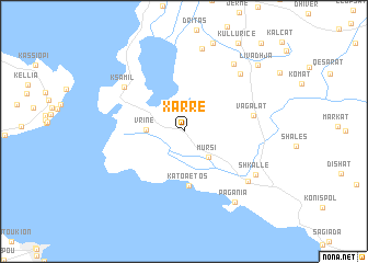
Xarrë (Vlorë, Albania)Xarrë is a town in the Vlorë region of Albania. An overview map of the region around Xarrë is displayed below.
regional and 3d topo map of Xarrë, Albania ::
Xarrë airports ::
The nearest airport is CFU - Kerkyra/corfu Ioannis Kapodistrias Intl, located 18.6 km south west of Xarrë.
Other airports nearby include IOA - Ioannina (66.0 km east), PVK - Preveza Aktio (108.2 km south east), KSO - Kastoria Aristotelis (131.6 km north east), KZI - Kozani Filippos (164.6 km north east), Nearby towns ::
Mursi (3.2km south east) //
Vrinë (3.0km west) //
(( Káto Aetós )) (5.6km south) //
Vagalat (5.7km east) //
Ksamil (6.5km north west) //
Sopik (7.3km north east) //
Çiflig (7.1km south east) //
Lefter Talo (7.9km north east) //
Shkallë (7.2km south east) //
Vurgu i Ri (8.6km north) //
(( Paganiá )) (8.2km south east) //
Livadhja (8.9km north east) //
[all distances 'as the bird flies' and approximate] 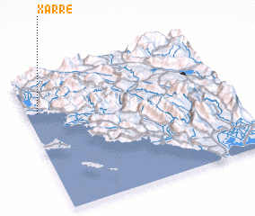 Places with similar names to Xarrë, Albania ::
Disclaimer :: Information on this page comes without warranty of any kind |
||
|
Where is Xarrë? Elevation and coordinates ::
Latitude (lat): 39°43'42"N Longitude (lon): 20°3'16"E
Elevation (approx.): 10m (map arrows pan, magnifying glasses zoom) |
||
|
Visiting Xarrë? Hotel/Accommodation ::
Book a hotel in Xarrë Travel Guide ::
Buy a travel guide for Albania rental cars ::
car rental offers GPS waypoint ::
download a GPX waypoint (PoI) of Xarrë for your GPS receiver
|
||