|
search place name
|
||
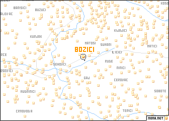
Božići (Federacija Bosne i Hercegovine, Bosnia and Herzegovina)Božići is a town in the Federacija Bosne i Hercegovine region of Bosnia and Herzegovina. An overview map of the region around Božići is displayed below.
regional and 3d topo map of Božići, Bosnia and Herzegovina ::
Božići airports ::
The nearest airport is ZAG - Zagreb, located 117.3 km north west of Božići.
Other airports nearby include ZAD - Zadar (133.7 km south west), SPU - Split (143.7 km south), SJJ - Sarajevo (167.5 km south east), OMO - Mostar (190.5 km south east), Nearby towns ::
Čengići (1.5km south) //
Sasina (1.4km north east) //
Žabariće (1.2km east) //
Grobići (1.5km north west) //
Pilježi (2.1km north) //
Rudine (2.1km north east) //
Kladovita (1.8km east) //
Topići (2.7km south) //
Kaurini (2.5km south west) //
Lugovi (3.0km north) //
Matoši (3.0km north) //
Vokići (3.2km south) //
Kruhari (3.2km south west) //
Zagaj (2.6km south west) //
Gornje Selo (2.8km north east) //
Tutići (3.1km south east) //
Šalići (3.3km south west) //
Nikići (3.7km south east) //
Gornja Trnova (3.2km west) //
Lukići (4.6km south) //
Rokvići (4.5km north) //
Poljak (3.7km south west) //
Škrljevita (4.1km south east) //
Ciganske Kuće (3.5km west) //
Majkići (4.8km south) //
Gaj (5.0km south) //
Arsenići (4.9km south) //
Tadići (4.5km south east) //
Kaurinovići (3.9km south east) //
[all distances 'as the bird flies' and approximate] 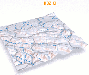 Places with similar names to Božići, Bosnia and Herzegovina ::
Disclaimer :: Information on this page comes without warranty of any kind |
||
|
Where is Božići? Elevation and coordinates ::
Latitude (lat): 44°47'43"N Longitude (lon): 16°43'33"E
Elevation (approx.): 225m (map arrows pan, magnifying glasses zoom) |
||
|
Visiting Božići? Hotel/Accommodation ::
Book a hotel in Božići Travel Guide ::
rental cars ::
car rental offers GPS waypoint ::
download a GPX waypoint (PoI) of Božići for your GPS receiver
|
||