|
search place name
|
||
Ivica (Federacija Bosne i Hercegovine, Bosnia and Herzegovina)Ivica is a town in the Federacija Bosne i Hercegovine region of Bosnia and Herzegovina. An overview map of the region around Ivica is displayed below.
regional and 3d topo map of Ivica, Bosnia and Herzegovina ::

Ivica airports ::
The nearest airport is SJJ - Sarajevo, located 72.1 km east of Ivica.
Other airports nearby include OMO - Mostar (80.2 km south east), SPU - Split (103.2 km south west), DBV - Dubrovnik (167.5 km south east), TIV - Tivat (200.0 km south east), Nearby towns ::
Jazvenik (1.3km south west) //
Skrti (1.3km west) //
Bilobučje (1.5km east) //
Planinica (1.5km north east) //
Čehaje (3.6km north) //
Nišan (2.8km east) //
Kordići (4.1km north) //
Struić (4.2km north) //
Kuljkići (4.1km north) //
Okolišće (5.3km north east) //
Pernice (4.7km east) //
Vasići (5.9km south west) //
Lugonje (6.2km south west) //
Laze (4.9km east) //
Bućevača (6.6km south west) //
Humac (6.4km north east) //
Šugine Bare (5.4km east) //
Gračanica (6.9km north east) //
Janjići (6.7km south west) //
Dražov Dol (6.0km north east) //
Osoj (6.6km south west) //
Bajići (6.3km south west) //
Zlavast (7.6km north) //
Radići (7.3km south west) //
Beče (6.2km north east) //
Tihomišlje (6.1km east) //
Šapine (6.6km north east) //
Donje Selo (7.7km south west) //
Topići (6.4km east) //
[all distances 'as the bird flies' and approximate] 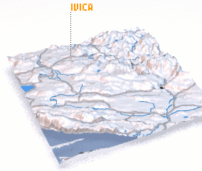 Places with similar names to Ivica, Bosnia and Herzegovina ::
Disclaimer :: Information on this page comes without warranty of any kind |
||
|
Where is Ivica? Elevation and coordinates ::
Latitude (lat): 43°56'42"N Longitude (lon): 17°26'59"E
Elevation (approx.): 947m (map arrows pan, magnifying glasses zoom) |
||
|
Visiting Ivica? Hotel/Accommodation ::
Book a hotel in Ivica Travel Guide ::
rental cars ::
car rental offers GPS waypoint ::
download a GPX waypoint (PoI) of Ivica for your GPS receiver
|
||