|
search place name
|
||
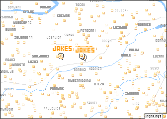
Jakeš (Bosnia and Herzegovina)Jakeš is a town in Bosnia and Herzegovina. An overview map of the region around Jakeš is displayed below.
regional and 3d topo map of Jakeš, Bosnia and Herzegovina ::
Jakeš airports ::
The nearest airport is OSI - Osijek, located 67.7 km north east of Jakeš.
Other airports nearby include SJJ - Sarajevo (128.8 km south), OMO - Mostar (192.1 km south), SPU - Split (225.3 km south west), Nearby towns ::
Jakeš (0.5km south east) //
Dobor (1.0km south) //
Tuk (2.5km north) //
Gaj (2.5km north) //
Gnionica (3.1km north) //
Tarevci (3.4km south) //
Jezero (3.0km north east) //
Rajlovac (3.5km north) //
Modrički Lug (2.7km east) //
Kamenjaši (3.3km north west) //
Srnava (4.0km north) //
Modriča (3.8km south east) //
Kužnjača (4.0km south west) //
Jazavac (4.4km north) //
Jakeš (3.3km west) //
Stanići (3.5km west) //
Cerik (5.0km north) //
Pećnik (3.9km north west) //
Samar (4.8km north west) //
Pecnik (3.9km west) //
Potočani (5.4km north) //
Čolići (4.1km north west) //
Kacević (5.7km north) //
Donja Dobrinja (5.3km south east) //
Kajinići (4.2km west) //
Riječani Donji (5.8km south) //
Cerova (5.9km south) //
Odžak (4.9km north east) //
Karamanići (4.7km south west) //
[all distances 'as the bird flies' and approximate]  Places with similar names to Jakeš, Bosnia and Herzegovina ::
Disclaimer :: Information on this page comes without warranty of any kind |
||
|
Where is Jakeš? Elevation and coordinates ::
Latitude (lat): 44°59'0"N Longitude (lon): 18°16'42"E
Elevation (approx.): 111m (map arrows pan, magnifying glasses zoom) |
||
|
Visiting Jakeš? Hotel/Accommodation ::
Book a hotel in Jakeš Travel Guide ::
rental cars ::
car rental offers GPS waypoint ::
download a GPX waypoint (PoI) of Jakeš for your GPS receiver
|
||